Contents:
1 – General Infomations
Romean roads
Franciscan trails
St Michael’s trails
Rome Santiago Jerusalem
Cammino della Luce, itinerary and connection with other pilgrim routes
Connections between Assisi and other pilgrim routes
2 – Along the “via Amerina” today
- Signposts and indications
- Cammino della Luce by bike
- Food and lodging
- Credential and Testimonium
- Tourist Information
- Level of difficulty – Emergencies
3 – Cammino della Luce from Aquileia to Perugia/Assisi
general informations
- From Aquileia to Venice
- From Venice to Ravenna
- From Ravenna to Assisi
4 – Cammino della Luce stage by stage
Perugia/Assisi – Roma
Roma – Assisi/Perugia
The stages
Terminology
connection from Perugia to Assisi
- visit of Assisi
- bypass from Perugia to Deruta
- from Assisi to Deruta
- from Deruta to Todi
- from Todi to Castel dell’Aquila
- from Castel dell’Aquila to Amelia
- from Amelia to Orte
- from Orte to Gallese
- from Gallese to Castel Sant’Elia/Nepi
- from Castel Sant’Elia/Nepi to Campagnano
- from Campagnano to La Storta
- from la Storta to Rome
5 – Maps
6 – GPS
General Informations
Cammino della Luce as a “Romean” road
In the Middle Ages the roads that the pilgrims traveled to reach Rome were called “Romean” (or Roman, or romipete), in honor of the city that was their final destination and the most important site, together with Jerusalem and Santiago de Compostela, of the Western Christian World. The Italian peninsula was crisscrossed by a dense network of roads that led to Rome connecting the ancient Consular roads and their ramifications with the major cities, castles, monasteries and religious sites along the way where pilgrims could find refuge, and where they could visit the holy places of the Defenders of the Faith and the relics of Martyrs.
A Romea road “par excellence”, so to speak, was the one that followed the Adriatic coast from Aquileia (called, since antiquity, the second Rome) and passing by Ravenna headed to the eternal city through the “Byzantine Corridor “, the narrow strip of land that during the VI, VII and VIII centuries united the Exarchate of Ravenna with the Roman Duchy and whose backbone was represented by the Via Amerina, the straightest and shortest way to Rome (now, approximately, replaced by the A45 highway from Orte to Venice). At Aquileia and in this direction (Concordia Sagittaria, Padua – Via Annia) the pilgrims met the other routes connecting to Eastern and Northern Central Europe.
Depending on the political situation, the weather or other specific reasons, wayfarers and pilgrims could however also follow other directions in the thick network of available roads.
One can, therefore, speak of a Nonantolan Romea, a Sambucan Romea, a Teutonic or Stade Romea (by the name of the abbot Albert of Stade, author of a pilgrim diary, which is kept in Hanover) that led down from the Brenner Pass to Ravenna and passing by Bagno di Romagna headed towards the Casentino area through the Serra Alpes; and others, like the same Flaminia which started from Rimini – one of the most important ancient cities of Umbria and final destination of other two important Roman roads, the Emilia and the Popilia. The Emilia, on its way to Milan, also connected with other Roman roads from the main centers of Northern Italy and several mountain passes.
The primary romean route used by pilgrims from the West was, of course, the Via Francigena which takes its name from the fact that it conveyed or came from the lands of the Franks. In fact, also in this case it would be more correct to speak in the plural of this road, as there were multiple routes that intersected the main line. In 1994, the Via Francigena was declared “Cultural Route” by the European Council. The road connecting most European countries between Rome and Canterbury was traced on the basis of the account, made by Archbishop Sigeric, on the return trip from his pilgrimage to Rome in the year 990 A.D., where he had gone to receive the pallium from the Pope. Diaries such as the one kept by the Archbishop of Canterbury during his voyage of approximately 1600 km divided into 79 stages, were a common practice of ancient pilgrims. There are many other descriptions of trips made on different routes, but the European Council has chosen Sigeric’s route, as it is the oldest testified account to have reached us.
Today pilgrims from the East and North, instead of following along the Adriatic coast to Ravenna and then taking the route along the Byzantine Corridor and the Via Amerina, cut inland across the Apennines and reach Perugia or Assisi and there resume the Via Amerina or head for the Via Francigena which passes to the west of Lake Trasimeno in Umbria, along the Via Cassia. Many pilgrims coming from the Via Francigena, reach Siena, then head to Assisi and from there continue to Rome along the Via Amerina and the Cammino della Luce. Others still, arrive in Assisi by the connecting route from Loreto.
Via Francigena is synonymous of Via Francesca, a name given in most parts of Italy and at different times to direct routes to France, but not to be confused with the Franciscan pilgrimage routes dedicated to Saint Francis, a name that Pietro Bernardone gave to his son in honor of France which had made his fortune as a merchant and perhaps where Francis was born during one of the frequent business trips in that land.
Cammino della Luce as a “Franciscan” trail
According to the definition given by Bishop Paolo Giulietti and Gianluigi Bettin in the Guide to this route, though it isn’t a historical itinerary like the Camino de Santiago, or the Via Francigena and the Vie Romee, none the less the Franciscan trails are a series of pilgrimage routes established by a millenary tradition, documented by abundant travel literature as well as significant historic, architectural and artistic monuments. These routes were used by pilgrims to reach the main shrines dedicated to St. Francis after his death and following the imperial edicts had liberalized the cult. Although in some places the Franciscan Route follows the ancient Christian millennial pilgrimage roads, this trail is a new route, linking several of the many places that recall the passage, the preaching and work of St. Francis of Assisi and finishes at the tomb of the Seraphic Saint.
There are several routes that move from different parts and lead to Assisi, in the heart of Umbria, that follow the footpaths and the word of the Saint, the material evidence of his passage such as caverns, shrines, hermitages, convents and Franciscan communities.
Even the Via Amerina leading to Assisi is, therefore, a Franciscan road and is marked for the modern pilgrim with white and red stripes (from South to North). From north to south, as Assisi isn’t the final destination but a place of passage, the pilgrim should follow the usual red arrow and also the signs indicating the Cammino della Luce towards Roma caput mundi et lumen gentium.
Cammino della Luce as part of St Michael’s trails
The pilgrimage to the holy shrines of Saint Michael was regarded as the fourth most important, after the first three to Rome, Jerusalem and Santiago de Compostela. The Sacred Longobardorum Road, recently established, and the other imaginative Roads of the Archangel lack any historical basis; however, as the cult of the St. Michael was strongly felt in the Middle Ages, the shrines of his manifestation became established places of worshipped and destinations for pilgrim, such as Mont St. Michel between Brittany and Normandy, the sacred St. Michael near Susa and the Cave of S. Michele located on the Gargano, in Apulia. The three holy places were linked by pilgrimage routes for a the total of about 2000 km; everywhere there were intersections with other roads, so also for this pilgrimage route there existed a network of trails that connected the many minor shrines dedicated to the Archangel Michael. On the Via Amerina there are different sacred places dedicated to St. Michael, only three in the area of Amelia (Monastery of St. Michael Archangel of the Somaschi in the historic center, another near Sambucetole and a church located in the district of the same name, just outside the town). Another small shrine dedicated to St. Michael is located between Orte and Bassano in Teverina, along the oldest section of the Via Amerina, near Lake Vadimone. At Castel St. Elia a cave church dedicated to the Archangel stands on the site where hermits used to settle since early Christianity and where Benedictine Monks built the magnificent romanesque Basilica dedicated to St. Elia. In the Suppentonia valley there is the Sanctuary of Santa Maria ad Rupes, currently entrusted to the Congregation of St. Michael Archangel, founded in Poland by Bronislaw Markiewuczi.
But not far from Amelia, between the Via Amerina and the Via Flaminia, near the towns of Narni and Otricoli, in Schifanoia (a name of mixed Byzantine / Longobard origin linked with the transhumance that passed through the place), there is an important and very ancient church dedicated to St. Michael Archangel that is worth visiting, for the interesting wall paintings it contains. The Apsis depicts Pope John XIII (born in Narni), Otto I, his wife Adelaide, Princess Theophane and Otto II, historical existing figures that surely passed many times in the district and along the Via Amerina. (1) It is also on the itinerary of Franciscans Protomartyrs, that has a separate chapter in this website.
Rome Santiago Jerusalem
The ambition of this project and that of St. James of Compostela’s Confraternity (an organization based in Perugia and articulated in many Priories active on the entire Italian territory) is to restore the major historical pilgrimage routes that connected Rome to Santiago and Jerusalem by land and sea. The Via Amerina, the Byzantine Corridor and the Via Romea, connecting Aquileia to Rome, now called Cammino della Luce, is a fitting part in this project. In fact, it is possible to reach Rome from Santiago with the Via Francigena, then to go back to Assisi and Aquileia along the Cammino della Luce, then on to Jerusalem with the routes that cross the Balkans. Or, after reaching Rome through the Via Francigena and/or the Cammino della Luce, continue on the Francigena South of Rome until Brindisi and Santa Maria di Leuca (de finibus terrae); there it is possible to embark for the Middle East, reach a ports in Palestine and finally set foot in Jerusalem; or again from Bari or Brindisi it is possible to land in Durres and continue the pilgrimage through the Via Egnatia on to Byzantium (modern Istambul) and then along the ancient roads of Anatolia, Syria, Lebanon, Jordan, and Israel.

Cammino della Luce – from Aquileia to Perugia/Assisi km 490 + from Perugia/Assisi to Rome km 220/200 – Tot. km 700 approx.
Itinerary and connection with other pilgrim routes
The itinerary of the Via Romea, the Byzantine Corridor and the Via Amerina starts in Aquileia, in Friuli, traces the ancient Via Popilia and then it heads for Venice and Ravenna. Between these cities it also collects pilgrims from Brenner and the Alps in general, as well as from Padua, Vicenza and other North East Italian cities. It continues to Cesena, Sant’Arcangelo di Romagna, San Marino, Urbino, Fonte Avellana, Saludecio, Scheggia, Gubbio, Perugia, Assisi, Deruta, Todi, Amelia, Orte, Vasanello, Gallese, Corchiano, Falerii, Castel S. Elia, Nepi, Campagnano, Formello, La Storta through the territory of the so-called Byzantine Corridor on the ancient Via Amerina, until if finally reaches Rome.
This pilgrimage route, called Cammino della Luce, is structured on the example of the Camino de Santiago or the Via Francigena, actually joining this last route in the area of the ancient Mansio ad Vacanas near Campagnano di Roma.
Aquileia can be reached following other historic routes from the Eastern and Central Europe via Zagreb, Ljubljana, Graz, Budapest, Bratislava or other German cities such as Hamburg, Cologne, Leipzig, Dresden, Bamberg, Monaco.
Connections between Assisi and other pilgrim routs
Assisi is increasingly becoming a confluence and a crossroad in Central Italy of different routes that arrive or depart from this city.
- The Via Lauretana starts in Siena and connects Assisi with the Via Francigena and then continues to Rome through the Cammino della Luce and the Via Amerina, intersecting the Via Francigena between Nepi and Campagnano.
- From Assisi you can go to Loreto (Via Lauretana) www.camminilauretani.eu
- From Assisi you can take the Via Francesca della Marca from Ascoli Piceno and from there, if you wish, you can continue to Monte Sant’Angelo along the Adriatic coast.
- From La Verna , tracing St Francis steps, one can arrive in Assisi along the Cammino “di qui passò Francesco” which then continues to other Franciscan shrines in Umbria, on to the province of Rieti and to Monte Sant’Angelo www.diquipassofrancesco.it
- From Assisi there also is the Cammino di Roma, that goes to Rome through Rieti www.camminidifede.it
- Various Franciscans routes lead to Assisi in the footsteps of St. Francis, starting from North
(La Verna) or South (Greccio/Rieti). One of them is the Via di Francesco www.viadifrancesco.it; a second one is the Cammino di Francesco www.camminodifrancesco.it; and a third one is the Cammino di Assisi www.camminodiassisi.it. - From Florence you can reach Assisi along the 220 km of the Via Ghibellina, 11 stages under the care of the Tuscan Pilgrim Community www.comunitatoscanailpellegrino.org
- Stade’s Pilgrim Route (still not well identified, but in some parts very close to the Cammino della Luce in the stages between Ravenna and Romagna). It goes from Stade, Lower Saxony in Germany through the Brenner Pass to Padua, Rovigo, Ferrara, Ravenna, then heads for Arezzo through the Apennines and joins the Via Francigena in Montefiascone. It is the route described by the abbot Albert of St. Mary of Stade in 1250 www.viaromeadistade.eu (it does not go to Assisi but touches the western part of Umbria).
- Finally, we must remember that the Cammino della Luce is a Compostellan route, connected to Santiago though the Via Francigena in Siena www.confraternitadisanjacopo.it
Along the Via Amerina today
Signposts and indications
In addition to the classic red arrows visible at strategic points we are gradually signposting and waymarking the way in both directions using the following signes.


In Lazio it is also possible to follow most of the indications given by the Coprensorio of the Via Amerina and of the Ravines.


Starting from Rome heading to Assisi the Cammino della Luce is marked as Franciscan trail, with the typical white and red stripes (from south to north). From north to south (also north of Assisi) the waymarks to follow are the red arrows and the signposts of the Cammino della Luce, that will lead the pilgrim to Rome.
Cammino della Luce by bike
In principle, any Pilgrim trail between Assisi and Rome is viable also for those who want to travel by mountain bike. If travelling with a traditional bike, we recommend biking along the Provincial roads (indicated by the acronym SP followed by the number of the road) that connect the various stages, easily detectable on any commercial road map. The acronym SS indicates a State road.
Assisi – Deruta SP404 from S. Maria degli Angeli to Passaggio di Bettona, SP403 from Passaggio di Bettona to Torgiano (bivio Deruta), SP400 from Torgiano to Deruta.
Deruta – Todi SP383 (ex s.s. Tiberina) to Ponte Rio and then up to Porta Perugina.
Todi – Amelia SP379 starting fro Porta Amerina until Montenero and then SP39 to Dunarobba, at the crossroads to Avigliano Umbro and then from there along the SP37 to Castel dell’Aquila; finally SP38 to Amelia.
Amelia – Orte from Porta Romana the first 500mt along SP31, then SP8 to the border between the provinces of Terni and Viterbo, and then SP59.
Amelia – Penna in Teverina – Orte (variant) SP31 until the crossroads to Penna in Teverina, then SP32 e SP84 until Orte.
Orte – Vasanello – Gallese SP30 to Centignano, and then SP34.
Gallese – Corchiano – Civita Castellana – Castel S. Elia – Nepi SP73 to Corchiano, then SP29 to Civita Castellana, SP67 to Castel S. Elia and Nepi. For those wishing to reack Nepi without passing by Castel S. Elia: from Corchiano take SP29 and before reaching Civita Castellana at the crossroads with SS311 turn and go directly to Nepi.
Nepi – Campagnano SP38 until you meet the road to Ronci, follow to the road to Ronci untilti joins the SP37. At Settevene the road passes over the SS Cassia and becomes the road to Trevignano. As bikes are banned any access on the highway Cassia, it is necessary to then take the road back to Ripolo until the crossroad of Pavone, and then take SP10A that finally reaches Campagnano.
Campagnano – Formello – La Storta SP10A then SP12A to Formello and further on to SS2 Cassia antica, until La Storta.
La Storta – Roma SS2 to Giustiniana, the Via Trionfale until you cross via Leone IV. From there in 2 minutes you can reach Piazza San Pietro.
Obviously, those who wish to make the pilgrimage to Assisi starting from Rome will have to do the reverse trail. For bikers wishing to go north of Assisi we have not yet found the best route to be recommended. We will give the best information as soon as possible.
Food and lodging
Discriptions of the hospitality along the pilgrimage are given in the relevant pages of the single stages of the Cammino della Luce, as well as the Franciscans Trails of the Teverina Valley, Monti Amerini and Protomartyrs.
The Cammino della Luce and the Franciscan Trails stretch through inhabited areas and therefore there are many opportunities to find bars and food stores along the way where you can easily get drinks and other necessities. There are some stages, however, where distances between the towns are long, or the countryside is thickly wooded and scarcely inhabited and therefore it can be difficult to find water or bars for several kilometers. Therefore you need to stock up before you start on water and food. Also, some stage have simple accommodation that does not provide food, in which case it is necessary to be self-sufficient.
The lodging are of two types:
Monastic or parish lodgings Mainly furnished by parishes or religious orders at low cost and in some cases on a voluntary donation basis. For larger groups it is often provided for in public facilities, such as sports or schools camps. Early booking is always necessary and should contemplate an agreement on expenses and housekeeping costs. Pilgrims should always adopt a respectful behavior towards the personnel in charge of the facilities and should always leave the rooms in order. Donations are appreciated, albeit minimal and even if politely refused by the personnel, in order to help the reception of other groups and pilgrims.
Other accommodation Camping sites, hostels, B&Bs, hotels and holiday homes can be booked in advance, but can accommodate also at the last minute, especially if you are walking alone or in small groups. It is always best, though, to inform the management of the expected time of arrival.
In all lodgings the Pilgrim’s Credential must be presented upon arrival so that it may be duly stamped by the manager, thus helping the personnel along the route to identify the needs of the pilgrims. We further recommended that the pilgrim should maintain at all times a suitable behavior: we like to think that “a tourist pays and claims, while a pilgrim appreciates and thanks, even when paying for accommodation and services”.
Credential and Testimonium
The Credential is the Pilgrim’s passport: it is a document attesting the identity of the pilgrim. It keeps account of the intentions and the actual itinerary of the pilgrimage and distinguishes the true pilgrim from other travelers. It is issued by a religious authority and as such should be used with responsibility. In Italy the Brotherhood of St. James of Compostela has created its own credential and can issue the document directly to those who may require it. It is awarded to those pilgrims who decide to walk the distance on foot, or bike or horseback. No cost is charged at the moment of the issue but offers are welcome. The credential of the Brotherhood is a general document that covers all sacred destinations and therefore can be used to pilgrims on route to Santiago de Compostela, Rome, Jerusalem, or even Monte Sant’Angelo, Loreto, Assisi, etc. It may be issued by the head office in Perugia or one of the Priors located in every Italian region.
To obtain the credential please check the website www.confraternitadisanjacopo.it or contact the head office.
Confraternita di San Jacopo di Compostella
Sede: Via Francolina, 7 – 06123 Perugia
Corrispondenza: via del Verzaro, 49 – 06123 Perugia
Tel. 075-5736381 Fax 075-5854607
E-mail: segreteria@confraternitadisanjacopo.it
Sito Web: http://www.confraternitadisanjacopo.it
Pilgrims on their way to Rome may also require the credentials at the religious Association Ad Limina Petri www.adliminapetri.it
The Testimonium is the certificate of completion of the pilgrimage and is issued in Rome to:
- pilgrims that have walked the Cammino della Luce for at least 100 km (i.e. from Amelia):
- pilgrims that have biked the Cammino della Luce for least 200 km (i.e. from Assisi)
To receive the Testimonium the pilgrim must apply with his credential at one of the following offices:
Opera Romana Pellegrinagi
Piazza Pio XII, 9 (just outside the colonnade of St. Peter’s Basilica)
Tel. +39-06-69896384
Opening hours: Mon. to Fri. from 9 am to 6 pm / Sat. and Sun. from 9 am to 4 pm
Rectory of St. Peter
Entry to the Vatican City near St Peter, Piazza del Sant’Uffizio
Contact the Swiss Guard for Sig. Patrizio Menna, Tel. +39-06-69883731
Opening hours: Mon. Tues. Thurs. Fri. and Sat. from 9:30 am to 12:30 am
The pilgrims will be greeted in the palace of the Rectory and taken directly to the tomb of the Apostle Peter, and immediately after he will receive a certificate of completion of the pilgrimage.
For larger groups please book ahead.
If it should not be possible to enter the Vatican City on arrival, the Testimonium may be applied for by mail at the Fabbrica di San Pietro, 00120 Città del Vaticano accompanied by the following documentation: a) photocopy of the Identity Card or Passport; b) place and date of birth and address of residence; c) copy of the stamped credential of the pilgrimage, with exact starting place with dates of departure and arrival and indication if it has been done on foot or by bicycle;
d) reasons for the pilgrimage. The Testimonium will be sent by mail at the specified address.
If the pilgrimage is from Rome to Assisi the Testimonium is issued to:
- pilgrims that have walked the Cammino della Luce for at least 100 km (i.e. from Amelia):
- pilgrims that have biked the Cammino della Luce for least 200 km (i.e. from Rome)
To receive the Testimonium the pilgrim must apply with his credential duly stamped at one of the following offices:
Basilica of St. Francis and Sacred Convent – Tel. +39-075-819001
Opening hours: daily from 8 am to 7 pm
Basilica of Santa Maria degli Angeli / Portiuncula
Tel. +39-075-8051430 – Fax 075-8051418 – email info@porziuncola.org
Opening hours: Monday to Saturday 9:30 to 12:00 /15.00-20.00 (vestry)
Sundays and holidays 9:30 to 12:00 /15.30 – 19:30 (museum).
Tourist Information Centers
Tourist Information Offices in Umbria
IAT Tourist Information Office of Perugia
also Corciano, Deruta, Torgiano
Piazza Matteotti, 18 – Loggia dei Lanari – 06100 Perugia
Tel. 0755736458 / 0755773210- Fax 0755720988
info@iat.perugia.it
IAT Tourist Information Office of Terni
also Acquasparta, Arrone, Calvi dell’Umbria, Ferentillo, Montefranco, Narni, Otricoli, Polino, San Gemini, Stroncone
Via Cassian Bon, 4 – 05100 Terni
Tel. 0744423047 – Fax 0744427259
info@iat.terni.it
IAT Tourist Information Office Alta Valle del Tevere and Città di Castello
also Citerna, Lisciano Niccone, Monte Santa Maria Tiberina, Montone, Pietralunga, San Giustino, Umbertide
Piazza Matteotti – Logge Bufalini – 06012 Città di Castello
Tel. 0758554922 – Fax 0758552100
Office in Umbertide Tel. and Fax 0759417099
info@iat.citta-di-castello.pg.it
IAT Tourist Information Office Amelia
also Alviano, Attigliano, Avigliano Umbro, Giove, Guardea, Lugnano in Teverina, Montecastrilli, Penna in Teverina
Piazza Augusto Vero – 05022 Amelia
Tel. 0744981453 – Fax 0744981566
info@iat.amelia.tr.it
IAT Tourist Information Office Assisi
also Bastia Umbra, Bettona, Cannara
Piazza del Comune – 06081 Assisi
Tel. 0758138680 / 0758138681 – Fax 0758138686
info@iat.assisi.pg.it
IAT Tourist Information Office Foligno
also Bevagna, Gualdo Cattaneo, Montefalco, Nocera Umbra, Sellano, Spello, Trevi, Valtopina
Corso Cavour, 126 – 06034 Foligno
Tel. 0742354459 / 0742354165 – Fax 0742340545
info@iat.foligno.pg.it
IAT Tourist Information Office Gubbio
also Costacciaro, Fossato di Vico, Gualdo Tadino, Scheggia e Pascelupo, Sigillo, Valfabbrica
Via della Repubblica, 15 – 06024 Gubbio
Tel. 0759220693 – Fax 0759273409
info@iat.gubbio.pg.it
IAT Tourist Information Office Orvieto
also Allerona, Baschi, Castel Giorgio, Castel Viscardo, Fabro. Ficulle, Montecchio, Montegabbione, Monteleone di Orvieto, Parrano, Porano, San Venanzo
Piazza Duomo, 24 – 05018 Orvieto
Tel. 0763341772 – Fax 0763344433
info@iat.orvieto.tr.it
IAT Tourist Information Office Spoleto
also Campello sul Clitunno, Castel Ritaldi, Giano dell’Umbria
Piazza della Libertà, 7 – 06049 Spoleto
Tel. 0743218620 – 0743218621 – Fax 0743218641
info@iat.spoleto.pg.it
IAT Tourist Information Office Castiglione del Lago
also Città della Pieve, Magione, Paciano, Panicale, Passignano sul Trasimeno, Piegaro, Tuoro sul Trasimeno
Piazza Mazzini, 10 – 061 Castiglione del Lago
Tel. 0759652484 / 0759652738 – Fax 0759652763
info@iat.castiglione-del-lago.pg.it
IAT Tourist Information Office Todi
also Collazzone, Fratta Todina, Marsciano, Massa Martana, Monte Castello di Vibio
Piazza del Popolo, 38-39 – 06059 Todi
Tel. 0758956227 – 0758942526 – 0758945416
info@iat.todi.pg.it
IAT Tourist Information Office Cascia
also Cerreto di Spoleto, Monteleone di Spoleto, Norcia, Poggiodomo, Preci, Sant’Anatolia di Narco, Scheggino, Vallo di Nera
Piazza Garibaldi, 1 – 06043 Cascia
Tel. 074371147
info@iat.cascia.pg.it
Tourist Information Offices in Lazio
(only for the areas crossed by the route)
ROMA
E.P.T. Tourist Information Office
Via XX Settembre 26 – 00186 ROMA – Tel. 06421381 Fax 0642138221
I.A.T. Tourist Information Office
Via Parigi 5 – 00185 ROMA – Tel. 06488991 Fax 064819316
VITERBO
A.P.T. Tourist Information Office
Piazza S. Carluccio 5 – 01100 VITERBO – Tel. 0761304795 Fax 0761220957
I.A.T. Tourist Information Office
Piazza Verdi 4/A – 01100 VITERBO – Tel. 0761226666 Fax 0761346029
RIETI
A.P.T. Tourist Information Office
Via Cinthia 87 – 02100 RIETI -Tel. 0746201146/7 39 – 0746201146/7 Fax 0746270446
I.A.T. Tourist Information Office
Piazza Vittorio Emanuele – 02100 RIETI – Tel. 0746203220
Level of difficulty – Emergencies
The Cammino della Luce/Via Amerina and the related Franciscan Trails of the Teverina Valley and Monti Amerini and Franciscan Protomartyrs passes on roads and paths that have no particular difficulty, even in bad weather. Some parts cross rural areas and hills that are wooded and isolated compared to the populated centers. As a rule it is best to cross the isolated stages during the hours of light and possibly in the company of other pilgrims, especially for those not particularly used to travel alone.
Pilgrims should bear in mind that it is not always possible to reach the Cammino with a jeep (though it is possible to get quite close practically everywhere along the route) because the trail fords creeks, crosses ravines, steep terrain and some areas delimited by barriers and fences to restrict car traffic. Therefore any motorized means of support for organized groups can not follow the entire route of the pilgrimage, but in some places is forced to make small deviations that will be indicated in the reference map.
For any difficult situation and emergencies dial the following telephone numbers
Mountain Rescue (for the mountainous areas) 118
Medical emergency service 118
Fire Brigade emergency1515
Carabinieri emergency 112
Police emergency 113
CAMMINO DELLA LUCE FROM AQUILEIA TO PERUGIA/ASSISI
general informations
From Aquileia to Perugia/Assisi 490 km approx.
As already explained, that the Cammino della Luce originates in Aquileia and leads to Rome, but it may also take the pilgrim from Rome to Jerusalem, via the land route through the Balkans. During the past ten years the Foundation of the Cammino della Luce has organized the stages that go from Perugia/Assisi to Rome, but in the future it will focus on the completion of the trail, extending it towards the north.
Meanwhile, pending the completion of the route, we have collected the experiences of various pilgrims who have already walked the complete pilgrimage. We have also followed the suggestions of members of the Confraternity of Saint James of Compostela, an organization with Priories in the regions of Friuli, Veneto, Emilia Romagna and Marche that has great knowledge of the territory, of the historical routes, and accommodation facilities most suitable for pilgrims wishing to stretch north to Aquileia. On the basis of these suggestions, the following is a list of the principle roads between Aquileia and Assisi and useful websites with more information, tips and news.
From Aquileia to Venice – total distance 120 km
Contact Associazione Triveneta Amici di Santiago, Monselice, www.amicidisantiago.it
Stage 1 – from Aquileia to Precenicco: distance 33 Km, time: 9 hrs (Aquileia, Monastero, Terzo di Aquileia, Cervignano, Torviscosa, Villanova di San Giorgio, Nogaro, Carlino, bosco Baredi, selva di Arvonchi, Precenicco)
Stage 2 – from Precenicco to Concordia Sagittaria: distance 22 Km, time: 6 hrs (Precenicco, Paludo di Latisana, Latisana, San Michele al Tagliamento, Giussago, Concordia Sagittaria)
Stage 3 – from Concordia Sagittaria to San Giorgio di Livenza: distance 17 Km, time 5 hrs (Concordia Sagittaria, Sant’Alò, Borgo San Pietro, San Giorgio di Livenza)
Stage 4 – from San Giorgio to Livenza a Jesolo; distance 27 Km, time 6 hrs (San Giorgio di Livenza, Revedoli, Cortellazzo, Jesolo)
Stage 5 – from Jesolo toVenice: distance 21 Km, time 5 hrs (Jesolo Cavallino, Ca’ Savio, Punta Sabbioni – Venezia)
From Venice to Ravenna – total distance 136 km
Contact Hanns A. Hoefer, http://camluce-it.blogspot.it/
Stage 1- from Venice to Chioggia: distance km 18 [boat to Lido S. Maria Elisabetta,
then on foot to Lido Alberoni (km 10), other boat to S. Maria del Mare, then again on foot to Pellestrina (km 8) and finally by boat to Chioggia]
Stage 2 – from Chioggia to Rosolina; distance km 20
Stage 3 – from Rosolina to Mesola: distance km 23
Stage 4 – from Mesola to Abbazia di Pomposa: distance km 15
Stage 5 – from Abbazia di Pomposa to Comacchio: distance km 20
Stage 6 – from Comacchio to Casal Borsetti: distance km 22
Stage 7 – from Casal Borsetti to Ravenna: distance km 18
From Ravenna to Assisi – total distance 234 km
Contact Gianni Piccioni, cell. +-39-340-5483981 Pilgrim Hostel Saludecio, Sant’ Amato Ronconi
Stage 1 – from Ravenna to Cesena: distance 33 km
Stage 2 – from Cesena to Santarcangelo di Romagna: distance 20 km
Stage 3 – from Santarcangelo to Romagna a Saludecio: distance 34 km
Stage 4 – from Saludecio to Urbino: distance 23 km
Stage 5 – from Urbino to Cagli: distance 26 km
Stage 6 – from Cagli to Fonte Avellana: distance 18 km
Stage 7 – from Fonte Avellana to Gubbio: distance 31 km
Stage 8 – from Gubbio to Valfabbrica: distance 32 km (from Gubbio to Perugia 39 km)
Stage 9 – from Valfabbrica to Assisi: distance 17 km (or 15 km)
CAMMINO DELLA LUCE STAGE BY STAGE
FROM PERUGIA/ASSISI TO ROME – FROM ROME TO PERUGIA/ASSISI
from/to Perugia approx. 220 km -from/to Assisi approx. 200 km
Terminology
E45 (superstrada) highway: very intense car traffic, 4 lanes
SS (strada statale) state road: intense car traffic, from four or two lanes, road numbers in the guide can be checked on the milestone
SR (strada regionale regional road: intense to medium car traffic, two lanes, road numbers in the guide can be checked on the milestone
SP (strada provinciale) district road: medium to low car traffic, road numbers in the guide can be checked on the milestone
Local road: asphalt road with very little car traffic
Dirt road: gravel road large enough for jeeps or tractors
Stone paved road: ancient Roman road paved with basaltic volcanic flat stones
Foot path: only pedestrian
Stream: medium water
Creek: very little water
From Perugia to Assisi (Km 20)
Road surface: asphalt
Walking time: 5 hours
Level of difficulty: easy
If coming from the Via Francigena (Siena) or from Gubbio, the connection to Assisi will take you through Perugia instead of Valfabbrica. You can follow the same path of the classic “Peace March” established by Aldo Capitini in 1961 that kicks off from Giardini del Frontone, exits Perugia from Porta S. Costanzo and heads for Assisi through Ponte San Giovanni, Collestrada, Ospedalicchio, Bastiola. You can also follow the route of the “Via di Francesco” which is well signposted.
Starting from the Cathedral (Piazza IV Novembre) (1) turn right onto via Ulisse Rocchi and Piazza Piccinino, then downhill on Via Bontempi. Continue on Via del Duca which becomes Via del Carmine on turning left and then Via dell’Asilo, turn right on Via Dal Pozzo for about 1800 meters, you can admire the templar Convent of St. Bevignate (2). Once at the New Cemetery (3), turn right on Strada di Montevile. Continuing on this road reach Ponte San Giovanni near the Ponte Vecchio (the Old Bridge) (4) and cross it. If, however, you want to go to the Hostel of Pieve di Campo, once you have taken Strada di Montevile, you must turn right on Via Valiano and then turn left. From Pieve di Campo take the railway underpass on the right and then take Via Manzoni on your left in the direction of Via Bixio. At the second roundabout go along Via Ponte Vecchio (4). Cross the bridge over the Tiber then go left along Via della Valtiera that runs along highway E45. Take the first underpass on the right and turn left onto Strada Ospedalone St. Francesco that leads to Collestrada (5), Centrale Umbran Road, then turn left on SR147, underpass the E45, then right and all straight to Assisi. From Collestrada to Assisi there is no need for special instructions because you can see the Basilica of San Francesco of Assisi, in plain view from the road.
If you want to avoid the asphalt road, there is an alternative footpath slightly longer, easy to detect along the road. However, once you arrive at Ponte San Vittorino (6) (on the left there is a hotel restaurant by the same name), head towards Piaggia San Francesco, with signs of the Cammino della Luce, taking a narrow road that climbs to Porta St. Pietro (7) and from here after 200 mt you arrive at the Convento and Basilica of St. Francis (8).
From Assisi to Perugia (km 20)
From the Gate of S. Pietro (7), take to the right, down the Piaggia San Francesco up to the San Vittorino mBridge (6), continue on SR147 to Collestrada (5). Take the underpass of the E45 on the left, then right on Strada Centrale Umbra and Ospedalone St. Francesco; Again cross the E45 with the underpass on the left, then take Via della Valtiera that runs along the E45 to Ponte Vecchio (4), a bidge on the Tiber. Cross the river, then if you want to go to Pieve di Campo turn left on via Bixio, follow via Manzoni and the railway underpass on the right. From Pieve di Campo take via Valiano until you reach the Strada di Montevile, continuing up to the New Cemetery and then Via Dal Pozzo (3) that will take you to the historical center of Perugia. If you do not intend to pass by Pieve di Campo, after crossing Ponte Vecchio (4) at the roundabout turn left into Via Ponte Vecchio, then the first right on the Strada di Montevile continuing after the New Cemetery along Via Dal Pozzo (3) to the historical center of Perugia. (2-1)
ACCOMMODATION
Pilgrim accommodation
Ponte San Giovanni, Parish of the Pieve di Campo, Tel. 075-5990566, email benpg@hotmail.it (self sufficient single and very small groups)
Assisi – Hospital of St Giacomo e St Francesco managed by the Brotherhoo of St James of Compostella of Perugia, Via Egidio Albornoz 31 (Old Cemitary) tel. 075-5736381 or 340-7597549, email segreteria@confraternitadisanjacopo.it, www.confarternitadisanjacopo.it, cell. of the manager 345-0343174
Parish of St. Rufino, tel. 075-812283, for large groups
Seminario Regionale Umbro, tel. and fax 075-813604 email rettore@seminarioumbro.it, large groups
Parrocchia di Santa Maria Maggiore tel. 075-813085 single to small groups
Casa Emmaus, Suore Missionarie Francescane di Assisi, via san Francesco 17, tel 075-812435/815119, email info@assisicasaemmaus.it, web www.assisicasaemmaus.it, single to small groups
Hostels and camping
Camping Village Assisi (3 km from the center of Assisi), Via San Giovanni in Campiglione, 110 – 06081 Assisi, Tel. 075-813710/816816, info@campingassisi.it – info@hotelgreenassisi.it
Camping Fontemaggio (800 metri from the center Assisi on the road for the Eremo delle Carceri, on Monte Subasio) via Eremo delle Carceri 24 – 06081 Assisi, tel. 075-812317/813636, fax 075-813749, email info@fontemaggio.it
Youth Hostel – Ostello della Pace – via di Valecchie 4 – 06081 Assisi, tel. 075-816767, email info@assisihostel.com, assisi.hostel@tiscalinet.it
Ostello Victor, in Rivotorto di Assisi – via della Spina 06080 Rivotorto di Assisi tel. 075-8064526
Hospitality in Religious Institutions
Cittadella dell’ospitalità Pro Civitate Christiana, Via degli Ancajani 3 –Assisi, tel.075-813 231 fax 075-812 445, www.cittadelladiassisi.it
and many other solutions on the website www.assisionline.it case religiose
Other accommodation
Hotel Fontanella, Via St Maria della Spina 18, 06081 Rivotorto di Assisi, tel. 075-8064182 , cell. 393-9134410
for other solutions search www.assisionline.it, or www.hotelassisi.com and on various other tourist information websites.
Recomended Restaurants (in the Old Town)
Pizzeria Bibiano, Viale G. Marconi 1 (near Porta St. Pietro) tel. 075-812639 and 812185, ask for Paolo
Trattoria al Camino vecchio, Via San Giacomo 7 (near Porta San Giacomo and Sacro Convento) tel. 075 812936
For any other touristic information contact IAT ASSISI Servizio Turistico Associato piazza del Comune 22
06081 ASSISI Tel. 075 812534 fax 075 813727 info@iat.assisi. pg.it
Other useful addresses in Assisi
– Libreria Zubboli: http://www.mauriziozubboli.com/ è in piazza del Comune, fornita delle guide di Terre di Mezzo, mappe e quant’altro di utile per il pellegrino. – Antica Farmacia dei Caldari: piazza del Comune 44, telefono 075 812552 del farmacista Pietro, pellegrino.
VISIT OF ASSISI
Any person arriving in Assisi must devote at least two days to visit the most important places of the city and surrounding areas, to better understand the world of St. Francis and its beauty. Pilgrims can easily find a suitable English Guidebook in the many book stores and shops in town or ask the tourist office for maps and leaflets. We suggest the following itinerary for the best enjoyment of the visit.
First day
The pilgrimage in the city of Assisi with the deviations towards San Damiano, located few hundred meters outside the city walls, is about 4.5 km in total.
- Chiesa Nuova /House of Pietro di Bernardone/Oratory of young St. Francis, Opening hrs: 6:30 – 12 / 14:30 – 17 (18 summer hrs)
- St. Maria Maggiore (old Cathedral), Opening hrs: 8:30 – 17 (19 Easter to November)
- St. Damiano, Opening hrs:10 – 12 / 14 – 16 (18: 30 summer hrs) open also from 7 for Mass
- St. Chiara, Opening hrs: 6:30 – 12 / 14 – 18 (19 summer hrs.)
- St. Rufino (new Cathedral), Opening hrs: 8 – 13 / 14 – 18 (15 – 19 summer hrs.) Easter week 7 – 19
- Tempio della Minerva/S. Maria della Sapienza, Opening hrs: weekdays 07:15 – 19:00, holydays: 08:15 – 19:00, Tuesday and Friday closed from 14:00 to 17:15
- St. Stefano, Opening hrs: 8:30 – 17:30 (21:30 est.)
- St. Giacomo de muro rupto, Opening hrs: does not have a precise opening hours, ring the bell, if the sisters are not engaged they will open; or call Tel. 075-811236 / 811236.
- Pilgrim Oratory, Opening hrs: 10:00-12:00 / 16:00-18:00 – closed on Sundays
- San Pietro, Opening hrs: 8 – 18 (19 summer hrs.)
- Basilica di S. Francesco, Lower Church, Opening hrs: 6:30 – 18 (18:50 weekdays in summer 19:15 holydays in summer); Upper Church, Opening hrs: 8:30 – 18 (18:50 weekdays in summer 19:15 holydays in summer)
Second day
The itineray goes from Assisi to the Eremo delle Carceri (km 3), then to the Abbey of San Benedetto on Monte Subasio (km 6), to St. Vitale/Viole (km 8), Rivotorto (km 10), Santa Maria Maddalena (km 12) and then finally to Santa Maria degli Angeli (km 14).
- Eremo delle Carceri, Opening hrs: 6:30 – 18 (19 est.)
- Abbazia of St. Benedetto
- Church of St. Vitale (Viole di Assisi)
- Santuario di Rivotorto (Tugurio), Opening hrs: 7 – 12:15 / 14:30 – 19:15
- St. Lazzaro in Arce /St. Maria Maddalena, please book the visit in advance, tel. 075-804429 / 8044293.
- St. Maria degli Angeli/ S. Maria la Porziuncola, Opening hrs 6:15 – 19:45 (6:15 – 12:30 and 14:00 – 19:45 summer) from July to September open also 21:00 – 23:00. Saturday open at 21:15 for the Rosary and Procession.
************
From Perugia to Deruta, without passing by Assisi (km 20)
(direct connection with the via Francigena from Siena or Gubbio)
Road surface: asphalt
Walking time: 5 hours
Level of difficulty: easy
From Perugia to Ponte San Giovanni follow exactly the same road indicated for the stage Perugia-Assisi until the old bridge on the Tiber (Ponte Vecchio sul Tevere) (4). After crossing the bridge, instead of turning left towards Assisi, continue on the right on Via del Sottopasso, turn left on via Ferriera (SP401) and continue until Torgiano (13). At the intersection with Via Assisi, continue straight on Via di Ponterosciano (SP403). Cross the bridge over the Tiber, turn right on Via Roma (SP400) where you connect with the Cammino della Luce arriving from Assisi, then continue to Ponte Nuovo (14) and Deruta (15).
From Deruta to Perugia, without passing by Assisi (km 20)
Follow the Via Tiberina south, then Via Francescana and Via Roma (SP400) crossing the village of Ponte Nuovo (but not the actual bridge on the Tiber) (14) until you cross via the Ponterosciano (SP403) ( 13) di Torgiano. At the intersection with Via Assisi head straight along via Ferriera (SP401) up to the underpass of the E45 in Ponte San Giovanni. Cross Ponte Vecchio (4) then continue on the same road from Assisi through Pieve di Campo (left via Bixio, via Manzoni, railway underpass on the right). From Pieve di Campo take via Valiano until you reach Strada di Montevile, continuing up to the New Cemetery and then Via Dal Pozzo (3) that will take you to the historical center of Perugia. If you do not intend to pass by Pieve di Campo, after crossing Ponte Vecchio (4) at the roundabout turn left into Via Ponte Vecchio, then the first right on the Strada di Montevile continuing after the New Cemetery along Via Dal Pozzo (3), then San Bevignate (2) to the historical center of Perugia and the Cathedral (1).
From Assisi to Deruta (km 23)
Road surface: asphalt
Walking time: 6 hrs
Level of difficulty: easy
Starting from the center of Assisi (from any given place; Piazza del Comune, St. Rufino, St. Chiara, Sacro Convento, St. Damiano) head towards the the Church of St. Pietro (we recommend a visit of this church, also taking into account the final destination of pilgrimage) and then leave the city by Porta San Pietro (St. Peter Gate) (7). Crossed the square (meeting point for tour buses and underground car park), take the stairs that go down to the so-called “bricked road”, the reconstruction of the paved road that went from Assisi to the Porziuncola and follow it to the Basilica of St. Maria degli Angeli (9). On the further side of the large square in front of the church, cross the main road at the roundabout and take Via San Bernardino da Siena, straight up to Tordandrea (10). Cross the town (taking Via della Portiuncula and Via del Santo Patrono) at the first intersection you can see a chapel (St. Rocco and St. Anthony), turn right on Via St. Simeone, and continue in open countryside. At the first crossroads (11), turn left on Via Ose, continue on Via Torte and merge with SP404 (via Assisi) just two hundred meters before the bridge over the river Topino, continue until you reach Passaggio di Bettona (12).
At the roundabout in front of the church of the Madonna del Ponte you go right to Signoria di Torgiano along SP403, continue towards Torgiano to the junction Pontenuovo-Deruta (13), turn left onto the SP400 to Pontenuovo (14) and continue for Deruta (15).
Note: you can avoid approximately 3.5 km SP403 between Passaggio and Signoria, turning right (at the second roundabout from the church of the Madonna del Ponte, approximately 500 mt) on via Ponte di Ferro and then taking Via Salceto. This road connects with SP403 in the vicinity of Signoria. If you decide to arrive at the Sanctuary of the Madonna dei Bagni, the total distance is 25 km, because this church is 2 km south of the industrial area of Deruta.
From Deruta to Assisi (km 23)
From Deruta (15) take the old Via Tiberina for Pontenuovo (14) and continue straight for Torgiano. Once at the crossroads of Torgiano (13), do not enter the town but turn right towards Bettona. Once in Signoria do not go to Bettona, but continue along the flat road towards Passaggio di Bettona (12). When you have reached the unmistakable silhouette of the modern church of the Madonna del Ponte (whose façade is an image of Christ), turn left and cross the bridge over the river Topino. Shortly after you leave the busy street and turn into via Torte and later in via Ose. At the crossroads with via St. Simeone (11) take to the right, towards Tordandrea (10) and reach it near a sacred shrine dedicated to St. Rocco and St. Anthony. Once you have crossed the town, go along Via del Santo Patrono, via the Porziuncula and Via San Bernardino da Siena and arrive at St. Maria degli Angeli (9). To get to Assisi take the “bricked road” to the Gate of St. Pietro (7).
ACCOMMODATION
Pilgrim accommodation
For single pilgrims, or small groups: Santuario della Madonna dei Bagni (located about 2 km after Deruta, near Casalina tel. 075 973 455). The hostel is run by a Caritas rehab community, visitors are therefore required to behave appropriately, abstaining from smoking and introducing alcohol of any kind within the precincts. If compatible with the activities of the centre, visitors can eat dinner and breakfast with the community (inquire in advance with the managers).
For larger groups, contact the Municipality, tel. 075 9728611.
Other accommodation
Deruta – Hotel Melody situated the km 55.800 of the SS E45, tel. 075 9711022 / 075 9711186, fax 075 971 1018, cell. 349 455 1081 www.hotelmelody.it
Agriturismo Alveare di Mari Giancarlo exit ss E45 Deruta Sud, via della vigna 7, tel. 347 3407859 fax 075 9710176 www.alveareagriturismo.it
Food
Along the main road, close to the ceramic industrial sites, you can find some pizzerias and takeaways.
ENVIRONMENT
After leaving Assisi (300 mt) from S. Maria degli Angeli, the itinerary leads through an area substantially flat, in a valley at an average altitude of about 200 meters above sea level, walking along suburban street until Tordandrea, then 5 km of country road to Passaggio di Bettona, followed by a provincial paved road to Deruta / Madonna dei Bagni.
SIGHTSEEING
The Bricked Road is the original route that connects the two most important shrines of the saint, the Basilica of S. Francesco and S. Maria degli Angeli. The ancient road that led from the city to the church of the Porziuncula was used at the end of St. Francis life and soon after his death it became a pilgrim route. The first pavement dates from the early ‘400 and consisted of a paved central path for pedestrians and two side lanes for the carts. The importance of the road in the time is confirmed by a further improvement in 1667 when all along the bricked road where planted a line of elms in order to shade the way for the pilgrims. Important sections of the ancient paving are now under the asphalt of the road. The recent renovation, ordered by the City Council of Assisi, was made possible by the help of millions of people around the world who donated a souvenir terracotta brick engraved with their name to the town. Today it is a fascinating trail, not only for the religious value but also for the landscape and the unique perspectives of Assisi it offers to the visitor.
The Porziuncola and the Cappella del Transito (Chapel of the Passage) of the Basilica of Santa Maria degli Angeli (Church of St. Mary of the Angels)
In the convent’s adjacent cloister is the rose garden where the Saint overnight, taken by strong doubts and repentance, rolled naked. According to tradition, the roses in the garden, at contact with St. Francis’ body, lost all their thorns so the saint would not hurt himself. Even today, the rose bushes are thornless. Continuing the visit you can see a statue of the saint with the doves resting in his hands and a cave, which according to tradition was the home of St. Francis.
A curiosity: Los Angeles’ (CA) original name was El Pueblo de la Iglesia de Nuestra Senora la Reina de Los Angeles sobre la Porciuncula de Asís, a settlement founded by Franciscan missionaries in the New World. San Francisco has the same origin as La Misión de Nuestro Padre San Francisco de Asis.
Deruta is a town mainly known for its ceramics and pottery production but it also has a beautiful historical center and numerous cultural sites. Very interesting is the Regional Museum of Ceramics where, among other things, a ceramic tile dated 1594 from the Ospedale di S. Giacomo (Hospital of St. James), located along the ancient Via Amerina, can be admired
SPIRITUAL PLACES
The Porziuncola is considered the cradle of the Franciscan congregation, where the saint finally matured his vocation, welcomed S. Chiara and the first brothers and finally died in God’s Grace. In the year 1216, the Porziuncula was granted by Pope Honorius III a plenary indulgence for all the pilgrims who, having repented and confessed their sins, visited the shrine from on August 2. During a night in July, while St. Francis was praying in Porziuncula, he had a vision of Jesus and Mary, surrounded by a host of angels. The apparition asked the Saint a wish and he pleaded for forgiveness for all sinners who had visited the church. The request was granted, through the intercession the Holy Mary. The next morning Francis went to Perugia with Brother Masseo where the new Pope had been recently elected and was granted the indulgence but only for one day of the year, the 2nd of August. Indulgence that today it can asked in all Franciscan churches and parish of the world. Since that time the Porziuncola became a place of pilgrimage from all over the world.
The Sanctuary of the Madonna dei Bagni was founded in the XVII century and is located in the Parish of Casalina, near Deruta. It is currently run by the bishopric of Perugia – Città della Pieve that guarantees its opening to pilgrims. It is located about 2 km outside the town of Deruta and 1,5 km from Casalina, on top of a small hill, on the left bank of the Tiber River, in the countryside and near a grove of pines, acacias , oaks and cedars. Inside the grounds of the Santuary there is an oak with the Virgin’s miraculous image, object of veneration and pilgrimage, as well as more than 700 artistic tiles left by devotees in memory of the graces received.
The origin of this sanctuary is recorded in a manuscript kept in the archives of the Abbey of St. Peter in Perugia. In 1643 a Franciscan friar passing by the “Colle del Bagno” (named by the spring located along the road where the travelers used to cool off and swim) noticed on the ground a piece of painted tile with the image of a Madonna with Child; to avoid it being trampled on, he picked it and placed it on a branches of an oak. Fourteen years later it had fallen back to ground, and a haberdasher from Casalina, Cristoforo di Filippo, took it home before bringing back and fixing it again to the same oak. Two years after, haberdasher’s wife fell seriously ill and the man asked the image of the Madonna to spare his wife. He returned home to find her healed, intent on housework. As a thanksgiving offering for the grace, they hung on the tree a newly painted tile. From that moment a ceaseless pilgrimage of devotees has constantly added to the collection of votive ceramic tiles, which now completely cover the walls of the sanctuary.
From Deruta to Todi (24 km – ore km 22 from Madonna dei Bagni)
Road surface: asphalt
Walking time: 6 ½ hrs
Level of difficulty: easy but the last km is quite a steep climb
Easy route, just follow the old SS Tiberina, currently divided into various sections of provincial roads, which almost always run alongside the E45 highway.
The first village along the road is Casalina (17) with the church of San Girolamo (St. Jerome) on the main square and the adjoining ancient pilgrim hospital. After Ripabianca, at the junction (18) continue for Collepepe (19) and follow the SP383 to Pantalla. After Collepepe ignore the road signs for Todi on the right and go straight until you reach Acquasanta (20). On the right, near the Tiber, the small church of the Madonna of Acquasanta with fresco by painters from the Siena school of the XVI century. Taking the SP83 you reach Pantalla (21) follow along the same road keeping the E45 on the left. A the overpass (22) cross the E45 and then keep the same highway on the right. A Pian di Porto go strait along the road that goes parallel to the E45, in the proximity of the Hotel Euro Palace (23), turn right and take the underpass on the road that goes towards Orvieto, at the foot of the hill topped by the town of Todi. At the first crossing, turn left for Ponte Rio (24), cross the village and just after a bridge over a small stream (25), turn right and tackle the very steep climb that takes you into Todi (just over a km). The road passes near the ancient cemetery and enters the town from Porta Perugina (26).
Note: we recommend that you should follow the route, even if on provincial roads, because of the little traffic on the road and because there is no other alternative at present. We’re still trying to find a foot path along the river: once it should be defined it will sure improve the experience of the pilgrims.
From Todi to Deruta (24 km – ore km 22 to Madonna dei Bagni)
Leaving by Porta Perugina (26), take the steep slope that goes down to Ponte Rio (25), cross the village until you get to the E45 underpass (24). Through the underpass in front of Hotel Europalace (23) head to the left, ie towards Pian di Porto / Deruta along the old national road Tiberina which almost always runs along the E45, at first on the left side, then after crossing the overpass (22) keeping the highway on the right, but always remaining on the left bank of the Tiber. Cross the villages of the Pantalla (21), Acquasanta (20) Collepepe (19) Ripabianca (18) Casalina (17) and arrive in Deruta (15). Stop at the Church of Acquasanta (20) and the Sanctuary of the Madonna dei Bagni (16).
ACCOMMODATION
Pilgrim accommodation
Parish of the SS. Crocifisso – for single pilgrims and small groups tel. 075 8944232 – 3486063169 (don Marcello)
Montesanto’s Franciscan Convent – viale di Montesanto, 18 -06059 Todi (Perugia) tel.075.8948886 (the convent also has some single and double rooms at reasonable price). Email monsanto@libero.it website www.conventomontesanto.it
At the sport grounds of the Church of Santa Maria Assunta in Ponte Rio, Luca Rossini, cell. 334-3032129
For large groups contact the Comune for the use of the sports ground facilities tel. 075 8956226 (Social service) or Istituto Tecnico Superiore di Agraria “Ciuffelli-Einaudi” tel. 075-8959511, fax 075-8959539 ask for Mr. Santucci
Other accommodation
SS. Annunziata Holiday Resort held by the Serve di Maria Riparatrici, via S. Biagio 2, 06059 TODI tel. 075 8942268 fax 075 8943218 www.monastero.smr.it (rooms and restaurant for the guests or for special groups) situated in the old convent where the nuns live and work.
Food
In Todi there are fifty restaurants which offer a rich selection of typical Umbrian cuisine, but we recommend Gisella Monfardini’s Pizzeria Rotisserie “La Ruota” in Via G. Matteotti, 166 (near porta Porta Romana) tel. 075 8944049, for the excellent money value and the particular sensitivity of the employer for the pilgrims necessities, Pizzeria Rosticceria Italo, Piazza Bartolomeo d’Alviano 1, tel. 075-8942645 (near Piazza del Popolo), Pizzeria Ristorante Pozzo Beccaro, Via Menecali Abdon 6, tel. 075-8948473 (show the credential).
ENVIRONMENT
From Deruta Todi the treck follows the paved Tiberina road which runs virtually along the E45, on the left bank of the Tiber, and in fact on the ancient Via Amerina, now completely disappeared. Traces of the pilgrimage path are still represented by chapels and churches both right and left of the road.
SIGHTSEEING
The fortified village of Casalina, old dependence of the Benedictine Abbey of San Pietro in Perugia, with the Pilgrims hospice in the square, now a private home.
At Piedicolle the church of San Giacomo and at Acquasanta the church of the Madonna dell’Acquasanta, with an interesting fresco by an anonymous of the first half of the sixteenth century, depicting the Madonna and Child, St. John and other saints, including St. Sebastian and St. Rocco, evidence of the passage of the pilgrims along the Via Amerina. Another painting, placed on the side, shows the fording of Tiber, a circumstance confirmed by the presence of a nearby church dedicated to St. Christopher.
Todi is a beautiful town full of history and monuments, and is well worth a stop for a daily visit. Do not miss the Duomo and Piazza del Popolo, surrounded by buildings dating from the Middle Ages. Also very beautiful is the church of San Fortunato, with the grave of the bishop and martyr S. Fortunato, patron of the town. Other saints are buried in the church: the bishop San Cassiano and Jacopone, the Franciscan author of numerous Laude (religious poems in vernacular Italian) and the Stabat Mater. On the outskirts of the old town are the Tempio della Consolazione, attributed to Bramante, and the Church of St. Filippo Benizi of the Order of the Servants of the Blessed Mary or Servites, with the remains of saint transferred from the Convent of San Marco after his death in 1385, and finally the Church of Saint Francis with its adjoining monastery of the Sisters of Saint Clair, with a big fresco of the XIV century entitled St Patrick’s Purgatory. The convent is currently in charge of a community which also deals with the reception of pilgrims. Noteworthy is the Museum located in the upper floors of the Captain’s Palace.
St Patrick’s Purgatory
(text and photo courtesy of Saint Francis Monastery, Borgo Nuovo 30, Todi)
The fresco – one of the first iconographic representations of Purgatory, only a few decades after the Dante’s Divine Comedy – is one of the masterpieces of Umbrian painting of the XIV century. The fresco portrays the passage of souls from Purgatory to Paradise thanks to the mediation of Christ, the Madonna and of Filippo Benizi. The souls are received by Saint Peter, the guardian of the Heavenly City. This painting is inspired by the legend of St Patrick’s Purgatory a Mediaeval best-seller written by Henry of Saltrey (ca. 1180-1184) that appeared in several versions in various languages.
The legend relates of St. Patrick despondency, as he was unable to move the hearts of the Irish, and how he went off to a desert place on a mountain. There Christ showed him a well, whoever spent a night and a day in this dark and secluded place, moved by sincere repentance and faith, would be purged of all sins and would be permitted to see the tortures meted out to the evil in Hell and the rewards given to the good in Heaven. The place has been located by popular religious belief in Lough Derg (the Red Lake) on Station Island. Many penitents would enter this place in the following centuries, until in the XII century (the time of Henry of Saltrey), Owein, an Irish knight, visited the well. Almost simultaneously with the success of the legend, Lough Derg in the county of Donegal became the only Irish pilgrimage shrine known throughout Europe during the Middle Ages. A steady stream of pilgrims came this far even from the distant Hungary and Catalonia, hoping to have St. Patrick’s same vision. The pilgrimage has continued through the centuries until today and every summer pilgrims still go to Station Island for three days of prayer and penance.
The Legenda Aurea by Jacopo da Varazze, Bishop of Genoa, written approx 1260/ 1298, provided a summary of the same story. In Jacopo da Varazze’s version the name of the protagonist is no longer Owein but one more familiar to Italians: Nicola.
Above the mountain of Purgatory we can see St Patrick in sumptuous bishop’s robes allowing a man, the dominus Nicholaus, to look through an opening he has struck with his stick on the ground at the souls being purged. We read in Revelation: “The fifth angel opened the bottomless pit, and smoke rose from the pit as of a great furnace” (Rev. 9.2).
The Purgatory is portrayed as the cross-section of a large mountain, where the souls expiate according to the evils committed in life: we can see the “pits” of the seven capital sins arranged on two floors. On the upper part are greed, lust, pride. Lower are sloth, anger and envy; gluttony is missing due to damage to the fresco. The punishments are close to the Dantesque concepts of “retribution” and “analogy”, although the representations are more approximate and naive. At the time, the general conception considered the purgatory as a place where the pain was different from hell only for the duration: temporary in one, the other eternal. That’s why we see crocodiles or leviathan and bats – symbols of the devil – that torment the souls.
After expiating, the purified souls cross a bridge bristling with nails (the symbolism of the bridge is one of the most universal, representations of the transition from earth to heaven), and emerge all dressed in white. White is the color of the priesthood and resurrection: white were the robes of Jesus on the Mount of Transfiguration and white are the robes of the saved in the Book of Revelation.
The Virgin Mary places garlands of flowers on their heads. The graced look like children because, as we read in the Gospel of Matthew: “Unless you become like children, you will never enter the kingdom of heaven “(Mt 18,3).
The Madonna, wearing a rich mantle, is larger than the other figures to underline her importance and is surrounded by the twelve stars of the Apocalypse, etched in the blue sky. She wears shoes as a sign of royalty, and though there is no Child in her arms, as she bends with maternal gesture to help the saved souls in her station between the two saints painted next to her: St Peter and the Florentine Saint Filippo Benizi of the Order of the Servants of the Blessed Mary or Servites.
The Order had commissioned the fresco and wanted to highlighten the figure of Filippo, venerated by the population of Todi soon after his death. Filippo Benizi, was canonized only in 1671 by Pope Clement X, therefore in the picture he is shown with the rays of the blessed and not the halo of the saints. He is holding in his left hand an olive branch, symbol of the peace he donated to his followers in his lifetime. With his right hand he pushes the purified and crowned souls towards St. Peter who ushers them into the Heavenly City of Jerusalem, where they join the cheering chorus of angels praising Christ, winner over sin and death.
The door is small and narrow, as we read in the Gospel of Matthew: “Enter through the narrow gate. For wide is the gate and broad is the road that leads to destruction, and many enter through it. 14 But small is the gate and narrow the road that leads to life, and only a few find it.” (Mt 7,13-14)
The heavenly Jerusalem is depicted as a large and majestic palace with battlements. Inside the city, above the walls, a benedicating Christ is surrounded by a host of angels, eleven to be exact. They represent the Apostles, Judas excluded
At the heart of this wonderful and colored scene some angels hover in the sky and above them a triumphal arch, decorated with ribbon, geometric design and foliage, and two prophetic figures: on the right, the prophet Isaiah is holding a scroll the Inscription: “Comfort, comfort my people, says your God. Speak tenderly to Jerusalem, and proclaim to her that her hard service has been completed” (Is 40, 1-2) and left the evangelist Matthew with the inscription: ” Come, you who are blessed by my Father; take your inheritance, the kingdom prepared for you since” (Mt 25, 34).
Because of the falling plaster the date of the fresco lacks the last three letters, but as it is mentioned in some historical documents it can be safely dated 1346. His author could be a unknown painter of the Siena school. In the main figures of the Madonna, St. Peter and St. Philip, there are some affinity with the manner of Jacopo di Mino del Pellicciaio; it is not unlikely that he should have worked on the main figures while the rest is the work of aid. Lately, the fresco as been considered the creation of an unknown painter working in Todi in those years: the so called Master of Purgatory.
Finally, the room of the beautiful fresco is the choir of the Sisters of Saint Clair (which succeeded in 1600 to the Servants of the Blessed Mary) and the daily prayer of the nuns effectively renew the symbolism of this important work of art of inestimable historical, artistic and theological value.
SPIRITUAL PLACES
Just outside the city walls is the convent of Montesanto, for centuries the home of Franciscan Minor Friars, and before that of the Poor Clares. The large monastic complex, which sits gracefully on top of a hill and is surrounded by trees, has recently been partly transformed into a resort that offers spiritual retreats and religious courses for groups, families and individuals.
We recommend a visit to the Convent of the Servants of Mary (Serve di Maria Riparatrici) in the old town in Via San Biagio 2, in order to participate to the Holy Mass that is celebrated in the morning in the monastery of the Poor Clares (entry from the church of St. Francis adjoining the monastery), in the chapel with the fresco of St. Patrick’s Purgatory. It allows the pilgrim a time of intense “spiritual recharge”.
From Todi to Castel dell’Aquila (km 19)
Road surface: mixed, mostly dirt roads
Walikng time: 5 ½ hrs
Level of difficulty: medium
Starting from the central Piazza del Popolo (27) and leaving the old town through the Porta Amerina (also called Porta Fratta) (28), take Via St. Raffaele that leads rapidly downhill, after a short stop at the Romanesque church of S. Stefano, follow Via delle Piagge to Ponte Naia (29). Pass by the Chapel of the Beata Vergine del Perpetuo Soccorso, then follow the sign to Fiore (along the sports grounds) to the small church of Santa Maria delle Grazie, built by Antonio Di Domenico PGR in 1734 on a previous shrine of the 1500 (30). A little further on, take the dirt road to the left, along the banks of the Arnata stream, and head towards Torricella. Immediately after the only home you’ll find on the left along the uphill road, you meet a path that leads to a new walnut plantation, after which the road again enters the forest. At the first intersection, turn right in the direction of Ospedaletto di Vasciano (31) or the ancient hospital of S. Maria Maddalena. The road continues south along the right bank of the Arnata stream until you reach the beautiful Bridge of Pesciano (32), always keeping an eye on the hill in front for Torre Olivola (a strategic defense tower along the Via Amerina, characteristic of this part of the territory).
After crossing the bridge continue along the left bank of the Arnata to Ciuccio’s Mill (now called the Mill of the English) (33). About 100 meters after the Mill, the path again enters the thick woods, and after only 200 meters to the left, it fords the creek of Civitella, a tributary of the Arnata.
Crossing the creek, continue on the route of the ancient Via Amerina between thick woods, until you meet the wire enclosure of the Anguillara Co. Estate and then up to the bridge of the Falce (34), recently restored near the Olivieri/Pesciano Mill. After crossing the bridge, turn right and follow the climbing path that skirts the enclosure of the Anguillara Co. Estate until you reach the top of the hill, in front of the Mestaiola of Sismano (35) (a small shrine dedicated to St. Eurosia). Then you should head downhill towards Forte Cesare (39) and Castel dell’Aquila (40), that can be seen towards the south. Slightly to the left is also the small town of Avigliano Umbro with the unmistakable square tower of the aqueduct.
Alternative route: (2 km longer)
* at Ciuccio’s Mill, leave the road just before the building and head left towards the Arnata, that you must cross on a small pedestrian bridge, then follow the dirt road for about 3 km to the Olivieri/Pesciano Mill (this enables to bypass the fording of the creek of Civitella, that especially in winter has lots of water).
* at the Olivieri Mill you can follow for approx. 500 meters the left bank of the river , until you reach the remains of the bridge of the Falce (without crossing it) and then take the steep climb to the left that goes up to the Mestaiola of Sismano or, otherwise, you can head for the Mestaiola Sismano directly from the Olivieri Mill by the slightly longer but more comfortable alternative dirt road .
From the Mestaiola of Sismano (35) proceed along the road heading towards Castel dell’Aquila (literarily the Eagle’s Castle), through Osteriaccia (36), Poggio delle Mandorle (37) and Santomanno (38), always keeping on the right the unmistakable silhouette of the castle of Forte Cesare (39). When you pass by the industrial area, take the provincial road that leads to the village of Castel dell’Aquila (40), dominated by the Church of St. Giacomo (St. James).
From Castel dell’Aquila to Todi (km 19)
From the junction at the exit of the village, near the pharmacy, head north on the old road Via di Valle Molina. After about 400 mt take to the left on the paved road next to the sports facilities until you reach some werehouses. Take the gravel road with the largest werehouse on the left, towards the a small hamlet called Santomanno (38). At the first rural settlement go right, leaving behind the castle of Forte Cesare (39) that dominates the area, continue always along the same road uphill until you meet another dirt road (Poggio della Mandorla – 37) and head towards the right (Osteriaccia – 36 and Mestaiola – 35). The Mestaiola of Sismano, in the local dialect “small majesty” or sacred shrine, is dedicated to St. Eurosia, placed on the hill. From the Mestaiola of Sismano, continue in the same direction to the North taking the path downhill that is hidden by the trees until you reach the valley and meet the river Arnata, always skirting the fence of the Azienda Faunistica Anguillara; the road becomes increasingly steep and rough, at the bottom is an ancient bridge called Ponte della Falce (Bridge of the Scythe of the ancient Amerina) recently resaured (34). After crossing the bridge, continue always along the fence of the Azienda Agricola Anguillara, until fording a small creek (the ditch of Civitella, a tributary of the Arnata). Continue for about 100 m. in the woods, then on a dirt road and after about 200 m. pass next to a newly restored mill, called Ciuccio or of the English (33). Leaving the Arnata on the right continue on the same road until you get to a beautiful ancient humpbacked bridge (Bridge of Pesciano – 32). After crossing the bridge the road is fairly simple, because you take to the left and keep on the same road until ‘Ospedaletto of Vasciano (31), now incorporated into a newly built Country House. Continue on the same road for about 500/600 m. through fields and a small wood and then take the path that goes downhill to the left, through a walnut orchard and on the road that goes toTodi. If you were miss the turning you will still reach the same road a bit further up near an unmistakable sewage treatment plant. In this case turn to the left to the asphalt road, and then right to Todi that you can see on top of a very steep hill. Along this road you meet the shrine of Santa Maria delle Grazie (30), the shrine at Ponte Naia (29) and after the steep climb you will enter Todi from the Porta Amerina (28).
ACCOMMODATION
Pilgrim accommodation
For single and small groups: the parish center – Parrocchia di San Giacomo, contact the priest Don Piero, tel. 0744.933623 or cell. 3396531518 o Giovanni Giacinti 0744-935121 or Cristina Isidori 0744-935045.
For big groups: accommodation can be organized in the local gym (contact the Comune of Montecastrilli) tel. 0744.94791
Other accommodation
B&B la Terza Quercia, Vocabolo Vaccano 75/c, Castel dell’Aquila, 0744-935444, cell. 333-7225870, mail ornella.amadoro@libero.it, www.laterzaquercia.it, special discount for pilgrims
Appartamento Maccaglia with portico, ideal 4 pax (+3) at 1 km from the town in the country, tel 338-2989234, mail d.maccaglia@libero.it
Agriturismo “Poggio degli ulivi” loc. Poggetta, tel. 0039 3471720150
Volo resort, loc. Poggetta 41, tel. 0744 934011, www.voloresort.it
Food
in the village of Castel dell’Aquila you can find two supermarkets and one bar and in Località Valle Molina, just on the road to Avigliano Umbro (300 mt from the old village) there is a bakery, pizzeria Buscella (closed on Sunday morning and Mondays) tel. 0744-935390.
ENVIRONMENT
Most of the journey takes place in the beautiful Umbrian countryside and through a stretch of woods, fording a stream tributary of the river Arnata, and crossing some beautiful bridges of the Roman domination and the early Middle Ages.
SIGHTSEEING
The landscape is scattered with many castles and towers, the remains of the defence system of the “Byzantine Corridor”, some of which have now become villages.
SPIRITUAL PLACES
Ospedale delle Quattro Cappelle (Hospital of the Four Chapels)
Going towards Castel dell’Aquila, near Forte Cesare and Paragnano’s Castle, with a small detour you can visit the few remaining ruins of the Hospital of the Four Chapels that was in the vicinity of a regional market. In fact, according to the Chronicles , “in 1112, Rapizzo, Count of Terre Arnolfe, donated to the Abbot Berard of Santa Maria in Farfa’s Abbey, the hospital, near the Market, of the Four Chapels and all its annexes”, which included the church dedicated to San Leonardo.
On the 1st of June 1208, at the time of Innocent III, the delegations of the Todi and Amelia met at the Hospital to sing an oath of allegiance pledging Amelia offer every year a candle to fifteen pounds to the city of Todi on San Fortunato’s name-day.
An second important testimony (Wadding) reports that St. Francis stayed at this location. “At midnight, while praying in the cell next to the gardens of the Madonna degli Angeli in June of 1223, St. Francis of Assisi had a vision of the devil tempting him and saying: “Why do you want to die before your time? Why pray so much? More than once I told you that, since you are so young at the so called Church of the Four Chapels, near Todi you may exercise other penances for your sins”.
This testimony is very important because it confirms that St. Francis chose the Via Amerina as his main route between Rome and Southern Umbria, as attested by Luca Wadding, great scholar of St. Francis of the XVII Century.
Of the Hospital there are records in the archives since the XVII Century, then goods and furnishings of the church were assigned to parish of Avigliano Umbro. Currently the remain consist of just the outer walls of the church of good Romanesque building technique (Prof. Joseph Maccaglia, historical archives of the Diocese of Todi).
The parish church of Castel dell’Aquila dedicated to St. James
Castel dell’Aquila (literarily Eagle’s Castle), was founded by the City of Todi around 1294 as an outpost and strategic location on the border with Amelia. Inside the Castle, as was the custom at the time, they also built a church, in this case dedicated to St. James the Apostle and outside, just next to the entrance to the castle, a Chapel dedicated to St. Mary. James became the patron saint of the castle and consequently a relic of the Saint is kept in the church in a special wooden reliquary that is exposed even nowadays on the July 25 (name-day of St james) and in other special occasions related to the passage of pilgrims.
Also witnessing the devotion to the saint is the painting of the main altar, attributed to the painter Sensini, in which St. James is show carrying a stick with a shell, wearing pilgrim clothing. Another attestation of the devotion of the community to their patron is the new glass window placed near the altar, rebuilt in 1946 following the destruction of the previous one, blown up in the explosion of 1945 of the ammunition piled along the street by the retreating German army.
In the last few years, the parish community has given new impetus to their patrons anniversary feast and also build a statue dedicated to pilgrims in transit along the Via Amerina.
From Castel dell’Aquila to Amelia (km 12,5)
Road surface: mixed, mostly dirt roads
Walikng time: 4 hrs
Level of difficulty: medium
The distance from Castel dell’Aquila to Amelia is about 13 km, the route is quite easy and thoroughly marked with signs of the Cammino della Luce. It runs almost all flat or downhill, except for a slight rise from the bridge of Santa Maria in Canale to the ruins of the Castle of Lagoscello and another climb of about 1.2 km from the bridge of San Leonardo to the Capuchin Convent (formerly ancient hospital of St. James). For those taking the Franciscan Ways of the Amerini Mountains, with a small detour of a few kilometers, you can visit the Franciscan grotto, a shrine above Collicello, and the nearby ruins of an ancient Benedictine monastery (ask for information on the spot).
Coming from Castel dell’Aquila (40) follow the provincial road that goes towards Amelia, after 1.6 km, at a small shrine (41), take the dirt track on the right that runs along the stream of the Rio Grande to the bridge of Collicello (42). Briefly transit again on the provincial road to Amelia and at St. Maria in Canale (43) turn left after approx. 200 mt, on a dirt road to the right. Walk to the top of this road to Lagoscello (44) (on the right you can see a small lake at the bottom) and down until you meet again the same provincial road near the village of Sambucetole (45). Without entering the old part of the village, take the road with the indication Cappucini, that leads to a convent a Capucin Friars (46) built on a former pilgrims hospice. From the forecourt, the profile of Amelia can be clearly seen only 5 km away. Continue further on the same local road until you reach a dirt road along the banks of the stream Rio Grande (47), and follow it to a new wooden bridge, after crossing it there is a final brief climb to Amelia (48).
From Amelia to Castel dell’Aquila (km 12,5)
Starting from Porta Romana (48) follow along the walls in the direction of the fountain of Nocicchia and the park of the Rio Grande (47). Then climb up to the Convent of Cappuccini (46) and continue to Sambucetole (45). Just after Sambucetole take the dirt road on the right to the ruins of the Castle of Lagoscello (44). Follow the dirt road until you cross the provincia road at Santa Maria in Canale (43). On the other side of the provincial road you can see the ruins of an old bridge. Take the provincial road to Collicello (42), until your reach a dirt road on the left that runs along the banks of the Rio Grande. A the next crossing with the provincial road you see a holy image (41) and, ahead of you, Castel dell’Aquila (40).
ACCOMMODATION
Pilgrim accommodation
For single pilgrims or small/medium groups:
Fondazione per il Cammino della Luce – Antico Ospitale di Santa Maria de’ Laici tel. 339-4674993 (Giancarlo) 339-5827867 (Siro) 338-1984522 (Sandro) ww.camminodellaluce.it; Parish of San Francesco tel. 0744 982076
Parish of San Massimiliano Kolbe, 0744 982120 or Convento Francescano della SS. Annunziata, tel. 0744 970010. The Convent, located 4 km from Amelia, on the Via Amerina towards Rome, has reasonably priced rooms and can accommodate groups.
For large groups contact the Comune for the use of the sports ground facilities tel. 0744-9761 or the Associazione Sportiva Amerina tel. 0744-982656.
Other accommodation
Ostello Giustiniani piazza Mazzini, 9 – 05022 AMELIA tel. e fax 0744.981718 cell. 393/3763970 – 345/8360069 – 335/5644309 info@ostellogiustiniani.com – Only lodgings or food on request- accomodation in single, double, triple or quadruple rooms –excellent money value – special offers for Youth and lerge groups (minimum 20/30 persons with credentials)For large groups contact the Comune for the use of the sports ground facilities tel. 0744-9761 or the Associazione Sportiva Amerina tel. 0744-982656.
Hotel Anita via Roma, 31 – 05022 AMELIA tel. 0744.982146 fax 0744.983079
Bed and Breakfast La Villa via Roma, 38 – 05022 Amelia cell.3492925821 tel.0744.983222 fiorellafiorini@libero.it (5′ from Porta Romana)
B&B Le Cisterne piazza Matteotti,5 – 05022 Amelia Telefax 0744 982249 | Cell. 346 0833723
There are many other possibilities, for further information contact the tourist information board IAT AMELIA tel. 0744.981453 fax 0744.981566 email info@iat.amelia.tr
Food
Cheap food can be found at the bars, pizzerias and takeaways around the square XXI September (outside Porta Romana). Otherwise try Enoteca “Puntodivino” in via della Repubblica 25 that offers a tourist menu or La Locanda del Conte Nitto in via Angeletti, on the ground floor of an ancient building, the dining room has fragments of Roman walls in opus reticulatum and the original paving of the Via Amerina, local cuisine and seafood.
ENVIRONMENT
Entire route in the beautiful Umbrian countryside of the Amelia.
SIGHTSEEING
In this stretch the landscape presents several castles and towers: again the defensive system of the “Byzantine Corridor”.
Amelia is one of the oldest towns in Italy, some Roman historians in fact trace its origins back to 1134 BC. For those who can spare a day, it deserves a complete visit of its many historic buildings, the museumand archaeological sites, starting from the pre-Roman polygonal walls, and continuing with it churches. The Cathedral which houses among other things a copy, donated by Pop John Paul II on the occasion of the fifth centenary of the evangelization of the Americas, of the cross of Alessandro Geraldini (other two copies are one in Santo Domingo and the other in the Vatican Basilica, just in front of the bronze statue of St. Peter). Alessandro Geraldini, born of noble family from Amelia, intervened at the court of Castile to support the enterprise of Christopher Columbus and became the first resident Bishop of the New World in 1520. He started the construction of the Cathedral of Santa Maria la Menor in the city of Santo Domingo, where his remains are buried. The cross is a scale copy of the one brought to Santo Domingo by the Bishop in his early evangelization of the local inhabitants.
For a short time the Franciscan St. Maximilian Kolbe live here – as a result a parish church in the new part of the city is dedicated to the Saint.
Do not miss a visit to the ancient hospital of Santa Maria dei Laici (Lay), also home of the Foundation of the Cammino delle Luce. The Fraternity of Santa Maria dei Laici’s Statute was exhibited as an example of what an ancient statute could be in Rome on the occasion of the Great Jubilee of 2000.
Hospitali Amerini on the pilgrimage road
(From the eponymous publication of the Via Amerina and Byzantine Corridor Study Center by Emilio Lucci, September 2006)
At the end of the XIII century at Amelia there was at least one hospice for pilgrims named after St. James and, soon after the institution of the Jubilees, other two were added: a clear sign of how the ancient Via Amerina was still one of the most used routes to Rome or to Compostela, in order to fulfill a pilgrimage to these venerable sites.
The oldest was the one named after St. James de redere which stood on the loaction of the present Capuchin monastery, some kilometers north of the city. The term de redere could be translated as paved road. The first document to mention the site is dated 29th March 1156, when twenty citizens of Amelia donated a piece of land placed at the foot of Mount Piglio to Peter Bono and his partners, including a priest named Pietro di Franco, because they already ran the place “and they could open a hospital that would give accommodation to poor pilgrims”. In the following years other donations followed, involving other land in the area (a document date 1170 also speaks of stratam maiorem, a name that clearly indicates the adjacent ViaAmerina).
In another document dated 1218 the hospice Sancti Iacobbi de reddere appears in a list of properties that Pope Honorius III assigned to the Benedictine order, specifying that it was not looked after directly but rented. However, the proceeds were allocated to the management of the hospital, always entrusted to a Prior (1275) supported by some attendants.
In 1342, however, St. James Hospice was under the care of the nuns of St. Magno, a Benedictine convent still existing in Amelia, then under the jurisdiction of the Abbot of St. Paul. Over the following years, the nuns had to cope with numerous attempts at encroachment by local nobles, sometimes also supported by the bishop, until a sentence in 1359 finally settled in their favour the property of the church, hospice and surrounding lands. Over the centuries the hospital of St. James fell into disuse until it was bought in 1550 by the Capuchin Fathers who transformed it into the convent where they still reside.
The nuns of St. Magno continued welcoming pilgrims probably within the city, in rooms adjacent their monastery of St. Magno near Porta Posterola, probably in what is now the Church of the Confranternita di San Girolamo (Brotherhood of St. Jerome). In the church there is an interesting fresco of the Virgin Mary between St. James and St. Anthony Abbot that dates back to the XV and XVI Century, especially as St. James appears young and beardless (in contrast with traditional iconography that usually portrays him as a mature man). It is said that this fresco originally was at St. James Hospice.
In the XIV Century two new hospices were operating in Amelia. One situated in the church of S. Second, just outside the Roman Gate, and the other just outside the Gilionis Gate (the current Porta Leone, i.e. Lion Gate), created for the Jubilee of 1300. A further document of 1355 relates of a legacy of land and tower in a place now called Castellaccio, on the Via Amerina between Montenero and Totano, already owned by a dominus Carolus also know as Carlo Terribilis, eminent citizen of Amelia of the 1300, who became mayor of Florence. The bequest was for the Fraternity of Santa Maria dei Laici (St. Mary of the Lay) with an article that within the tower there should be built a chapel with the image of the Virgin and that three or four beds should be prepared for the poor pilgrims who passed along the Via Amerina.
Certainly the most important hospice in Amelia was the one linked to the Fraternity of Santa Maria dei Laici, within the city walls at a short distance from the main gate. Its origins date some time before the year 1300 and it kept on working on the same site until 1772, when Bishop Struzzieri, in agreement with the municipal authorities, transferred the hospice, that in the meantime had become a sanatorium, in the monastery of St. Stephen, where it is still currently operating as a public hospital.
Below are the first few lines (freely translated) of the Statute of 1355, conserved intact to this date, which clearly describe the original motivations of the institution.
“In the name of the Almighty God [….] the Holy Martyrs Fermina and Olympiade as well as the Virgin Saints and Martyrs John (the Baptist) and Catherine (of Alexandria), and all the Saints of the Church. Some lay people of Amelia, inspired by God, placed at the disposal of a refuge for the poor and pilgrims some of their houses with beds so that they may be received and accommodated free of charge in Amelia, in accordance with the principles and articles of the Fraternity of Saint Mary “.
At the beginning of 1500, thanks to another donation of the wealthy amerino merchant Pietro Racani, the adjacent Hospice of St. Antonio, so called because cared by the Canons Antoniani of Vienne, was created for the medication and care of pilgrims suffering from ignis terribilis a disease caused by the contamination of rye with the fungus claviceps, commonly known as ergot, a sometimes lethal infection that affected the limbs with necrosis and mummification, and the less dreadful disease of herpes zoster known as shingles.
SPIRITUAL PLACES
Convento dei Cappuccini, previously Hospice of St. James, dated XII century.
Convento della SS. Annunziata of the Franciscan Minor Friars
Monastero di S. Magno Benedictine cloistered nuns, where you can do spiritual exercises, prayer meetings, vocational research or simple visits and orientation interviews.
Monte del Salvatore with the via Crucis articled by Bishop Crispin in 1702, which grants plenary indulgence to those who attend it exactly as a pilgrimage to Jerusalem.
From Amelia to Orte (km 16 ridge route– km 18 valley r.)
Road surface: mixed, mostly dirt roads
Walikng time: 5 hrs
Level of difficulty: easy
From Amelia (Umbria) to Orte (Lazio) you may follow different paths: the first is the provincial road know as Ortana, joining the two centers in about 15 km. There are also other routes that have in common the first part until you get close to the border between the provinces of Viterbo and Terni (Umbria and Lazio), where you can opt for a valley road along the stream of the Rio Grande, or continue along the ridge. The two roads rejoin about 2 km before arriving at Orte.
We obviously do not recommend the provincial road and suggest to opt for the other two: the ridge road is shorter (about 16 km); the valley is a bit longer (about 18 km) but much more interesting from the natural (a sulphurous spring near the Rio Grande) and archaeological point of view, as it follows the ancient Via Amerina. Notably this second route passes near the remains of a Roman funeral monument and the ruins of the ancient port of Seripola, on the river Tiber, according to some studies the ancient Castellum Amerinum of the Tabula Peutingeriana.
Starting from Porta Romana (48) take the provincial road to Giove (named Via I Maggio in the vicinity of town) for about 3km to the Lourdes grotto in Montenero (49). From there, take the road of S. Silvestro and follow it for about 1 km and 400 mt. The last stretch runs along a large vineyard (50), which then meets the traces of ancient road that you can guess underneath the brambles, on the right. At the end of the vineyard, continue along the ancient route near some tall trees. Near a newly built villa perched on the hill, the road divides (as duly marked by the signs of the Cammino della Luce) (51).
- The ridge route: go left for 100 mt. until you reach the provincial road from Amelia to Orte,(52) take to the right and follow for about 2, 5 km, passing in front of the restaurants Campo Antico and Vecchia Fattoria and another house with a tower, all on the right, until after a curve you see a dirt road on the right in rapid ascent (53); take it and continue along the ridge keeping close a big building called Cimacolle (54). and then along the bottom of a fenced property Ciucci for about a kilometer to the crossroads with the main road coming from Penna in Teverina (55). Opposite you will see the indication of the ancient port of Seripola (61) (those wishing to visit it, must go down to the Tiber for 500 meters, passing a farm by the name of La Chiocciola and then return by the same way) (55). Continue for Orte, turning left on the provincial road for 700 mt and the then taking a dirt road on the right that descends toward the Tiber river and the motorway A1.
- The valley route: From point 51 turn right and descend the dirt road leading to a big farm called Rio Grande/Ayala (56), head to the dirt road through the fields until you meet some old oak trees. Turn left along the path that follows the ancient route of the Via Amerina (57), where ruins of an ancient Roman mausoleum emerges among the vegetation. Ford the stream Rio Grande, then turn immediately to the right and follow the dirt road along the vineyards until you reach a location with springs of volcanic origin (58), characterized by gas and sulfur. Continue along the right bank of the Rio Grande. If you wish you can make a stop in the pilgrim resting point of the Parish of St. Maria delle Nevi in Penna in Teverina, near the ruins of an ancient water mill (59). From here, if you want, you can go to Penna in Teverina, just 3 km away, where you can sleep in the parish hostle located in a beautiful spot, overlooking the Tiber valley, and continue the journey the next day. Otherwise, passing the pilgrim resting point, continue on the dirt road leading to the provincial road, cross it and continue downhill for approximately 300 meters until you reach a bridge over the Rio Grande (60); without going over the bridge, follow the signs, and ford the stream after about 500 meters. Continue on the left bank of the stream to the confluence with the Tiber, just beyond which you can visit the ruins of the ancient river port of Ameria/Seripola (61). The road then climbs up to the farm of La Chiocciola and again up to the provincial road, meeting point with the other route (55). Continue to Orte on the right, after 700 mt, then turn again right on a dirt road that descends toward the Tiber river and the motorway A1.
At the first intersection with a small local road, continue left for 1.1 km until near the Church of San Lorenzo (62), with documented evidence of the passage of St. Francis (the church is no longer opened for worship but the owned is available on request for visits). Then continue through an underpass and stop at a fountain with abundant water (63); 100 meters from the fountain, turn right on the provincial road, cross the Tiber and the motorway, and just after the bridge, at a curve, take the local road that climbs dramatically up to Orte, entering the old town through Porta San Cesareo (64).
From Orte to Amelia (km 16 ridge route– km 18 valley r.)
Start from Porta San Cesareo (64) go down to the bridge over the Tiber River then take immediately left along Via dell’Acqua Acetosa (63), take the highway underpass to the Church of St. Lorenzo (62), continue to the left for about 700 meters up to a dirt road on the right that leads to the main road to Penna in Teverina. Go right up to the junction for the ancient river port of Ameria in the area of Seripola (55). At this point you can take the ridge road on the right, through the vineyards until Cimacolle (54) and continues until you get onto the SP Amelia Orte (53) near the border between the provinces of Viterbo and Terni (Lazio and Umbria) and from there (52), you can either continue along this road to Amelia or along the ancient Amerina road that lies between two properties, (51) until another big vineyard called Pizzogallo (50), after which you meet, near St. Giuseppe, the dirt road of St. Silvestro which ends in Montenero (49) on the SP that leads to Amelia from Giove (48). Alternatively you can follow the valley road along the Rio Grande, of higher historical and environmental interest. From the junction to the port of Seripola (55), you can reach the site of the archaeological excavations on the Tiber (61) passing through the property of La Chiocciola. Continue along this road near a place called Castiglioni along the Tiber River and the stream Rio Grande until returning to the SP to Penna, near the bridge over the Rio Grande (60). 300 m. after the bridge take a dirt road to the right that goes to the Rio Grande, the Pilgrim resting point (59) and the sulphurous area (58). Follow on the right bank of the stream until it reaches a ford (indicated by a road sign) and after 100 meters you will encounter the obvious ancient route of the Via Amerina and the remains of an ancient Roman mausoleum (57 ). Further on, under large oak trees go to the right towards the Country House Rio Grande – Ayala (56) and then up to the meeting point with the ridge route (51). Next to the gate to the large property of Totano and two newly built houses surrounded by a wall of large boulders on the right, take the old route at the border between the properties marked by tall trees, until reaching the vineyard of Pizzogallo (50) and continue alng Strada di St. Silvestro towards Montenero (49) and Amelia (48).
ACCOMMODATION
Pilgrim accommodation
Penna in teverina – Casa di accoglienza della Madonna della Neve for singles and small groups, tel. 0744-993292 – 0744-993183, call the parish priest Don Antonino De Santis 340-4169374
Orte – Parish of S. Maria Assunta for singles and medium groups tel. Lorenzo Duranti 346-6115134
For large groups accommodation on the sports grounds or in the schools, call the Comune di Orte Tel. 0761.4041 / fax. 0761.493303 – E-mail. info@comune.orte.vt.it
Other accommodation
Penna in Teverina: Agriturismo “L’albero degli struzzi” owned by Lieggio Patrizia, via Ortana 58, cell. 333-45959565 or 347-3129450 or 329-3986530 email: patrizialieggio@alice.it
Agriturismo ”I segreti del borgo” via Penna Molino 27- info: 0744-993120, cell. 347-6147434 www.isegretidelborgo.it; email: info@isegretidelborgo.it
Orte – B&B La Torretta small apartments with a common kitchen. Breakfast in the dining room, Tel. 0761.402275 (discount for pilgrims with credentials)
B&B HORTA di Pellegrini Anna Maria (open from 1.3 to 31.12) discont with credentials, cell. 348 3367862 kappett@tin.it.
Food
In the old town of Orte we suggest the Trattoria da Saviglia, tourist menu with typical cuisine tel. 0761.402963. Various bars and food stores
ENVIRONMENT
The track passes through beautiful Umbrian countryside, the Tiber River valley and the countryside of Orte. At about half way it leaves the region of Umbria and enters Lazio. On the left is the backbone of the Apennine hills, right the Cimini hills and the Tuscian county; facing south stands the imposing profile of Mount Soratte emerging solitary from the surrounding countryside.
SIGHTSEEING
If you stop in Penna in Teverina, visit the Nativity of Penna, an artistic permanent Nativity with 140 statuettes, moving mechanisms made by local craftsmen and background music by the famous musician and singer Riccardo Cocciante.
Seripola, the remains of an ancient river port on the Tiber, has been identified by archaeologists as Castellum Amerinum, visible in the Tabula Peutingeriana (an ancient road map), a major Roman outpost on the Via Amerina. There are visible traces of the Spa facilities with their steam heating, the numerous ground floor stores where the goods from and to Rome where kept. The archaeological site, only partly recently excavated gives the visitor an idea of how a river port in Roman times worked as an exchange point.
In Orte don’t miss the Museum of the Confraternite (Brotherhoods) and the Diocesan Museum, where among other works is a painting of St. Francis, made by one of his contemporaries, that apparently a very close likeness of the Saint of Assisi.
The Passage of St. Francis in Orte in the year of the Lord 1209
Friar Thomas from Celano relates in his Chronicle of the life of the Saint, Vita Prima (Life Before), the joy of Francis and his first eleven companions when they had obtained from Innocent III, not without difficulty, the approval of the Monastic Rule they wanted to found. Just three years after the dramatic renunciation of his father in front of the bishop, in the square of Assisi, and one year from the beginning of his preaching to his first companions, St Francis had managed to receive the approval of his spiritual program from the Pope himself, who by the way considered the whole thing almost humanly impossible to follow. After praying on the tomb of St. Peter, Francis and his friends had taken the road to Spoleto, of course on foot, that would necessarily take several days. The Chronicle cites only one long stop at Orte for fifteen days. It was the year of the Lord 1209.
“The group settled,” writes Thomas, “in a place near Orte …. where some of them went to search for the necessary food and reported to others what little they had managed to scrape together by begging from door to door, and ate together pleased and thanking the Lord. The leftovers were either give to the poor, or stocked in a nearby tomb. The place was deserted and almost nobody passed that way”. This is all that was reported by the first chronicler of the Seraphic, from whose pages all other biographies have greatly drawn.
But it is what Thomas doesn’t say that has stimulated subsequent Franciscan historians. The twelve companions had already started reasoning that their lives and customs could be of example for future monks. One of the first issues they had to address was deciding If they had to live among men or retreat to the wilderness.
It is therefore legitimate to assume that the two weeks spent in Orte served to address this crucial points that has characterized, not always quietly, the great Franciscan Family (Abbondio Zuppante The hermitage of San Nicholas de scopulis in Cronos, year II, n. 3 July 2009).
However the elements to identify the exact location of the long rest of Francis and his companions are few. Among the Franciscans settlements founded in Orte and surrounding areas during the life of Francis and in the period immediately after his death, the one that fits the description of Thomas’ Chronicles is the site of the Church and adjoining hermitage of San Nicolao in scopulis (i.e. on the rocks) built in 1232. The site, on a natural ridge of rock overlooking the Tiber valley, has all the Franciscan amenities, such as ravines and grottos where the monks could retire to pray and several typical Etruscan and Faliscan rock tombs.
San Nicolao is, or rather was (because it was hit by accident during the aerial bombing of the train station in August 1943 that caused many casualties among the refugees from Orte that had taken shelter in the Church), just off the road that leads from Orte to Gallese, by way of Castel Bagnolo, a secondary route of the Via Amerina which unites with the main route in Corchiano or Falleri.
SPIRITUAL PLACES
At the old mill of Ciancare, near the sulfur springs of Penna in Teverina along the Rio Grande, in 2014 a pilgrim resting point was built on a piece of land belonging to the farm of the Albero degli Struzzi (Ostrich tree) owned by Paola Lieggio. It is worth a stop and a prayer for the beauty of the natural spot. At the base of the altar is a plaque with some words from the First Letter of St. Peter the Apostle.
Food
In the old town of Orte we suggest the Trattoria da Saviglia, tourist menu with typical cuisine tel. 0761.402963. Various bars and food stores
From Orte to Gallese (km 14,5) – (km 20,5 if passing by Vasanello)
Road surface: mixed, mostly dirt roads
Walikng time: 4/5 hrs
Level of difficulty: easy
From the Cathedral Square (65) proceed along the belvedere overlooking the Tiber and the motorway A1 to the site of a crumbled castle. If the Tiber does is low, you can see the remains of a bridge of the Via Amerina called Bridge of Pontaccio or of Augustus. Go down the road next to the arches of the medieval aqueduct that carried water to the public fountain in the square, cross the provincial road from Orte to Viterbo and take the stairs next to a fountain till you reach the provincial road that goes to Vasanello, thus avoiding some of the traffic.
You can go to Vasanello (73) taking the local road, and then after the Post Office, turn on to the road that leads to Castel Bagnolo (everybody will show you the way) in about 4 km. Otherwise you can go directly to Castel Bagnolo bypassing Vasanello, taking the small road that deviates on the left at the sign Azienda Agricola Castel Bagnolo (or bagnolese): this deviation is precisely at a curve just after the overpass of the highway to Viterbo that you will clearly see. Follow these signs for 4 km (towards south-south/east) until you reach Castel Bagnolo, where you can stop in the chapel dedicated to the Madonna of Loreto (67) (ask for the keys at the nearby house).
From Castel Bagnolo continue to Gallese by the dirt road until you see the monument of San Famiano (68), made by the Romanian sculptor Camillian Demetrescu and blessed by John Paul II. After stopping at statue of this great XII century pilgrim buried in Gallese (patron of the Via Amerina), continue by the road on the right. Once on the provincial road at the village of Valli (69), turn again right towards Gallese, for approx. 1 km. In Gallese you can visit the tomb of Saint Famiano (70) contacting the parish priest Don Remo or some member of the Brotherhood. Then go to the parish hostel next to the church of St. Maria Assunta (71).
You can also take a third way to Vasanello, through the archaeological area of Palazzolo: at Orte, immediately after the stairs next to the fountain that lead to the road to Vasanello, at an ancient milestone (66) turn right uphill to the small settlement of Le Grazie, cross it and continue along the gravel road for about 2 km until you reach the bridge over the highway to Viterbo. Turn right to return to the provincial road and go uphill towards Viterbo. Pass the junction of the highway and after a few hundred meters turn left, again passing the highway, towards the archaeological area of the ancient faliscan settlement of Palazzolo (72). The directions and the red arrows will guide you up to Vasanello (73), where next the post office you will find the small road to Castel Bagnolo (the distance between Orte and Vasanello is approx 9 km, while Orte Castel Bagnolo is approx. Km. 4).
At Vasanello there are some nice churches, St. Maria Assunta (X Century), San Salvatore (XI Century), the Orsini Castle (XII Century) and the chapel of San Lanno with frescos by Piermatteo d’Amelia.
From Gallese or Vasanello to Orte
From the Church of St. Famiano (70) go towards Gallese Scalo on the SP for about 1 km till reaching a place called Valle (69), then turn left uphill on a small private consortium road. At the crossroads at the monument to St. Famiano by Camillian Demetrescu (68), turn left, cross the barriers of the consortium and the old disused railway to reach Castel Bagnolo (67). Here you can make a brief stop at Giancarlo Vitali’s farm and visit the Church dedicated to Our Lady of Loreto. At Castel Bagnolo you can choose between two itineraries:
a) direct to Orte. Continue for about 2.5 km until you reach a crossroads (third right) named Piagge Alte (double check for the signpost). The road descends gradually, continue and take the provincial road Vasanello-Orte, near the highway overpass; go right towards Orte and till you reach the junctions with Le Grazie (66) and Orte (65).
b) to Orte via Vasanello. Take the so-called “Roman” bridge in Castel Bagnolo (ask the locals if you need help to find it) and from here continue along a gravel lane for about 4 km up to Vasanello (73). From Vasanello you can reach Orte by the provincial road (8 km) or you can take the road that runs through the archaeological area of Palazzolo (72) and then merges with the provincial road from Viterbo to Orte just next to the junction of the Orte-Viterbo-Civitavecchia highway. Just after the junction on the right take the the secondary road through the neighborhood Le Grazie, and reach the junction with the road from Vasanello (66) and go towards Orte.
At about a hundred meters after this junction take a shortcut to the right downhill that avoids the traffic. Going down, cross the main road and then go up to the old town of Orte through a parking lot next to the Agricultural Consortium. The road climbs along the medieval aqueduct arches which brought water to the town and continues along the belvedere (overlooking the Tiber and Motorway Autostrada del Sole). If the river is low in water you can see the remains of the Roman bridge of the ancient Via Amerina. Your destination is Piazza Santa Maria, in the centre of Orte (65). If you choose the first alternative the total distance is 14 km; if you choose the second it is 20 km.
ACCOMMODATION
Pilgrim accommodation
Parish of S. Maria Assunta “Casa di San Famiano” tel. 0761.495055 – 0761.496276 cell. Parish priest Mons. Remo Giardini 338-5205260 for single pilgrims or medium groups
For large groups contact the Comune tel. 0761.49791 fax 0761.497925 email info@comune.gallese.vt.it
Other accommodation
Agriturismo Giulia di Gallese Strada Cerreto snc – 01035 Gallese (VT)
Tel./Fax 0761.495510 – 333.6082071 info@giuliadigallese.com – www.giuliadigallese.com
Food
Recommended restaurant “ L’Angolo del castello” – piazza san Francesco 9, tourist menu with excellent value for money, special care for pilgrims with credentials, tel. 0761 495541
Various bars, pizzerias and food stores
ENVIRONMENT
After crossing the Tiber, you enter the province of Viterbo, characterized by the presence of the Cimini Mountains, a vast vulcanic area with medium high peaks and the vulcanic Lace of Vico, the highest in Italy, located 500 meters above sea level. The geological origin of the Cimini Mountains is to be attributed to explosive volcanic phenomena that still continue today with the many thermal springs in the area. The first phase of the eruption formed a stone known as peperino, a typical volcanic rock from the area; the latest geological period formed the more superficial tuffaceous rocks.
The tuff plate is very deeply incised by gorges and ravines, sometimes 100 meter deep, at the bottom of which are streams, direct or indirect tributaries of the Tiber that have eroded the tuffaceous plateaus in the course of centuries. In the gorges the cooler and wetter microclimate has strongly influenced the vegetation. Therefore in the bottom of the gorges we find species of plants normally present on hills, such as chestnut trees, alders, oaks, some species of orchids. While emerging from the bottom of the ravines the species become more and more typically Mediterranean, such as juniper, oak, arbutus and cistus. Today on the volcanic plains the main cultivations are olives, vines, and hazelnuts, a prized fruit much sought after by the leading confectionery industries.
Much of the land is included in a nature reserve established in 1982. There are many towns in the area, all of ancient origin. They are generally built on tuffaceous spurs bordered on two sides by ravines: a very valuable natural defense, that leaves only one side for defensive constructions, as can clearly be seen from an aerial photograph Nepi.
SIGHTSEEING
The Chapel of the Madonna di Loreto at Castel Bagnolo. If passing by Vasanello, the Cathedral, the Church of San Salvatore, the Orsini Castle and the Chapel of San Lanno with the frescos by Pier Matteo of Amelia, one of the most interesting painters of the Umbrian school of the IV century, that had been commissioned before Michelangelo to decorate the Sistine Chapel. He painted a great starry blue sky that was after replaced by Michelangelo’s frescoes.
SPIRITUAL PLACES
St Famiano
(by Anna Grazia Casali)
During the mid-twelfth century, exactly on the 17th of July 1150, there arrived in Gallese the Cistercian monk Quardus, born in 1090 in Köln from a rich and noble family. The town would remain forever conditioned by this event: the Monk stayed in Gallese for less than a month but his figure emerges with great authority in the legislative statutes (printed in 1575 in Gallese) and also in civil life.
When Quardus went on his long pilgrimage to Rome (at the age of eighteen), Europe was still a politically fluid body of young nations where everybody spoke a “vulgarized” Latin and felt strongly united to the Roman Catholic Church. The universal values of the Church made pilgrimages a very common practice of the times, regardless of age and class.
Quardus arrived in Rome the 27 of August 1108 when Pope Pasquale II (1099-1118) was ruling. He visited the catacombs and the most important shrines in Rome, and then continued to wander for six years in Italy, reaching all the major shrines of the peninsula. He then went to the tomb of the Apostle James in Compostella.
Before arriving in Santiago, he stayed for three years in a small monastery in Galicia dedicated to s. Antonio. He then decided to take vows and moved to a monastery dedicated to Sts. Cosmas and Damian in a forest along the river Mino where he remained for 25 years, living as a hermit.
In 1137 King Alfonso VIII of Castilla y Leon gave a small community of monks led by Abbot Garcia a mountainous area called Oseira, so they could built a monastery, together with a group of monks sent by Bernard of Clairvaux. In 1141 they founded the 154th Cistercian Abbey in Europe. In 1144 Quardus became a Cistercian monk of this Abbey. In 1147, at the time of the second crusade promoted by Pope Eugene III, he obtained a pilgrim license to the Holy Land, where he remained even after the return of the crusaders.
In 1150 he visited Italy on his way back to Spain, but arriving in Rome he had a vision of the Apostles Peter and Paul telling him go to the town of Gallese, where some of his brothers Cistercians had settled in 1143 and built, within the walls of the destroyed town of Falerii, the monastery and church of St. Maria.
He headed along the Via Amerina to Gallese, but one mile from the village, tired and thirsty, he beat his pilgrim stick on the ground and immediately a spring of fresh water gushed from a rock. The spring still cures the devotees in the spot of the miracle and is marked by a chapel dedicated to San Famiano. He arrived in Gallese, and was a guest of Ascaro, a man he had healed from a serious illness but he fell ill in turn and asked, on his death bed, to be buried in a small cave at the foot of the hill of Gallese, near a stream, telling the inhabitants that if they kept his body it would grant them miracles.
He forfeited his soul to God on the morning of the 8th of August1150 and all the inhabitants of Gallese brought the body to the cave. Around the spot where his body had been lain, dressed in Cistercians clothes, in the following centuries the inhabitants built a basilica dedicated to him, architecturally adapted to the site. The body was never moved from the original place where he asked to be placed, with his head still resting on a Bible. Four years after his death, Pope Adrian IV canonized the Saint changing its name to Famiano, for the fame of the miracles occurred on his grave.
From Gallese to Castel Sant’Elia (km 28)/Nepi (km 26)
Road surface: mixed, mostly dirt roads
Walking time: 9 hrs
Level of difficulty: medium, in some parts difficult because of the gorges
From the Church of San Famiano (70) take the road with the indication of San Famiano a lungo (75) (the small shrine located about 2 km outside Gallese) where you can still drink water from a miraculous spring and continue to Corchiano through beautiful hazelnut groves; when you arrive at the Madonna delle Grazie (76), continue until you reach the Roman stone paved Via Amerina, which comes from Vasanello in the area Musale a) (77); take the Stone road and continue to Corchiano. Here you have two possibilities.
1- Go through the outskirts of town to reach the Church of the Madonna del Soccorso (79) and the southern Etruscan/faliscan necropolis walking along the authentic Roman stone Via Amerina, until you reach the carved road (81) that comes from the village (80) and continuento the SP29 and the restaurant “Ragno Rosso” (82). At the electricity cabin, turn right and continue on that road, following the signs (red arrow and indication Via Amerina ) up to a field sloping down to a creek that has to be a forded.
2- Starting from the area Musale b) (78) go into the center of Corchiano (80) and then, close to the church of S. Egidio, take a picturesque “carved” road that leads, after crossing a bridge over the stream Fratta and another Etruscan carved raod (81), to the restaurant “Ragno Rosso” (82), then continue to the creek that has to be forded, as above.
Once you have crossed the creek, take a path on the right and after a few hundred meters, after skirting a kennel (83), you will meet the provincial road that goes from Fabbrica di Rome to Corchiano (near a field for motocross); cross it and go towards Falleri (84) and then to the archaeological site of Falerii Novi (85). Here are the archaeological remains of the ancient town and the basilica of St. Maria (Cistercian). The whole of the Roman city is crossed by the Via Amerina which forms the cardo, (main road in latin). Take the road to the modern housing development of Parco Falisco (86), cross it completely and follow the signs for Cavo degli Zucchi (87) (where the road is “carved” into the tuff), the most important and spectacular archaeological site of the ancient Via Amerina. In fact, it is the necropolis of Falerii (in the south of the city, located along the way). After admiring on the left the two most spectacular chamber tombs at the end of the long stone paved road, cross a wooden bridge held by metal tubes and continue along the old road until you reach the village of San Lorenzo (88). Leaving the restaurant “la Vecchia Quercia” on the left enter again into the ravine, or cut road under the ruins of the Tower of Stroppa, or of the Island. Cross a creek and climb on the other side making sure to take the left path, indicated as a mountain bike track. Carry on, without losing spirit for about 2 km, along the path that leads along the old road, easily recognizable by the excavated tuff and the caves and ancient tombs. When you come to a shooting range for archers (you can see the silhouettes of the targets), again go down and up a ravine crossing a small creek, until you emerge near a farm house in front of which passes a small road going East/West, always following the signs of the Comprensorio della Via Amerina.
At this dirt road, called “Via Pianella” (89), you can opt for two solutions.
1- Go direct to Nepi (91) that is easily reached by the ancient route following the signs, gates, fences and wooden bridges of the Comprensorio della Via Amerina (please close the gates after passing because of the grazing cattle, or use the pedestrian swing gates). The stretch of Via Amerina that enters the town of Nepi has been named Via San Paolo.
2- If instead you wish to head for the town of Castel S. Elia and the Sanctuary of Santa Maria ad Rupes (90), take the road to the left. We recommend this second solution in order to see this important Marian shrine.
Visit the stairway down to the Chapel of the Madonna carved by P. Rodio, a companion of St. Benedict Labre, and the underlying VII-VIII century Romanesque basilica of St. Elia. You can also ask for accommodation with the religious congregation of St. Michael the Archangel (Polish). Holy Mass at the Marian shrine is at 6pm.
At Nepi visit the catacombs of St. Savinilla with paintings of St. James and St. John the Evangelist in the tomb of St. Roman, martyr and patron saint of the city. Visit also the Museo Civico that displays important Faliscan, Etruscan and Roman art, opening days from Tuesday to Friday hrs 11:00 to 13:00 and from 16:00 to 18:00; Saturday and Sunday from 10:00 -13:00, 16:00 -19:00 in the summer and 15:00 18:00 in the winter (closed on Monday); Via Falisca 31 Tel. 0761-570604 email museo@comune.nepi.vt.it Visits can be booked in advance even out of normal opening hrs for groups telephoning 339.3272179. The visitors can also see the Rocca of the Borgia.
Alternative route from Gallese to S. Maria delle Grazie
There is a road that shortcuts about 4 km and goes directly from Gallese (70-71) to St. Maria delle Grazie (76) passing by the sport grounds, but we recommend you take the longer route passing by S. Famiano a Lungo and visit this highly spiritual place, linked to the first miracle of this most Holy pilgrim. At St. Maria delle Grazie you encounter the other route coming from Gallese. This route is a shortcut.
Alteernative route from Santa Maria delle Grazie to the north-eastern Canyon of Corchiano
This route shortcuts the stone paved road of Musale (77) and the Southern necropolis of the Madonna del Soccorso and opt for a route that crosses another beautiful stretch of Corchiano’s north-eastern Canyon, recently recovered and rendered accessible to the visitor. Basically, from Santa Maria delle Grazie you head towards the North Canyon (77 bis) descending through a steep carved road, continue along the Creek and then emerge at the center of the village climbing a modern staircase that leads to via Borgo Umberto I; then follow via Roma to the Church of Sant’Egidio (80), take the carved road that goes to the bridge on Rio Fratta, where it reconnects with the route from the Church of the Madonna del Soccorso and continue through a further carved road (81) towards the Ragno Rosso.
Alternative route from Vasanello to Corchiano
The ancient Via Amerina, at least in the year 241BC did not pass through Gallese, but went to Corchiano (the ancient Fescennium) and headed directly twards Orte and Amelia (through the present town of Vasanello (73) a faliscan pagus identified with the Castellum Amerinum of the Peutingerian Table). Therefore, the pilgrims today going to Rome can avoid Gallese, head directly to Vasanello from Orte (along the deviation to Palazzolo that replaces the original ancient road currently unapproacable marked in brown on the map) (74), and continue following the old road from Vasanello to Corchiano, where near the area of Musale (77) it rejoins the Cammino della Luce coming from Gallese.
From Nepi / Castel Sant’Elia to Gallese / Vasanello
Whether starting from Nepi (91) or from Castel S. Elia (90) go towards the ancient Via Amerina and follow the signs of the Comprensorio della Via Amerina e delle Forre that will take you at least until Corchiano (80). After 1 km from the town of Corchiano, just after a beautiful stretch of stone paved road in the area of Musale (78-77), you can go towards Gallese (70) by turning to the right, following the directions of the aforesaid Comprensorio and the white and red signs of the Franciscan Route, or turn left towards Vasanello (73) along the principal route of the ancient Amerina whose paved remains run from the side to the local road, bypassing Gallese as explained in the alternative routes of this stage.
ACCOMMODATION
Pilgrim accommodation
Per pellegrini singoli e gruppi medi: Pontificio Santuario Maria SS. ad Rupes, Piazza Cardinal Gasparri, 2 – 01030 Castel Sant’ Elia, VT tel/fax: 0761-557729 – 0761-557765, single and double rooms, on reservation you can have dinner and breakfast with the monks in the common refectory, special prices for pilgrims with credential
Convento dei Servi di Maria, Via Giuseppe Garibaldi 165, 01035 Nepi – tel 0761-557005 single and double rooms, special prices for pilgrims with credential
For large groups there is the use of the sports ground facilities.
Contact Comune of Castel St. Elia, via Umberto I 41, 01030 Castel S. Elia (VT) tel. 0761-556425 fax 0761-570152 – email segreteria@comunecastelsantelia.it
Comune di Nepi piazza del Comune, 01036 Nepi (VT) tel. 0761-55811 fax 0761-557960 – email municipio@comune.nepi.vt.it
Food
Various bars and take aways.
in itinere: Bar Orchidea via Roma 36, Corchiano; Gerry Caffè, via Roma 62, Corchiano;
Riz Bar (Pina) big space for large groups, Parco Falisco, tel. 0761-574445;
“La Bottega” (groceries, sandwiches) via Falerii Novi 3, Parco Falisco, tel. 338-1166560
ENVIRONMENT
The track passes on long stretches of the original Roman stone paved road of the ancient Via Amerina. Often the previous Etruscan/Falisco track, carved directly on the tuffaceous plate, can clearly be seen because of the grooves left by the cart wheels. The “carved” roads are very particular of this area, leveling the roads and allowing an easy crossing of the ravines.
SIGHTSEEING
The remains of the town of Faleri Novi
The town walls, built in 241 B.C., remains almost intact: 2,100 meters long with 50 of the 80 original towers still standing. Notable are the two, well preserved Gates: the Puteana or Bove Gate which opens to the south where the via Amerina enters (the top part of the arch is shaped and an ox head) and the so-called Jupiter Gate, a magnificent example of Etruscan architecture with a round arch with a keystone, a head of deity that resembles Jupiter (copy of the original is kept in Forte Sangallo, National Museum of Agro Falisco in Civita Castellana). The city was destroyed around 1100 by the Normans and its inhabitants returned to Falerii Veteres that had better defences, which then took the name of Civita Castellana.
To visit the ruins: free admission, always open. Enter the site by Jupiter Gate, then go round the basillica on the left, following the track that leads to the centre of the ancient city, or Forum, at the crossing of the two main streets: the Decumanus and the Cardo (the latter consisting of the Via Amerina that goes north – south).
Do not miss the Abbey with the Basilica of Santa Maria in Falleri, built between 1143 and 1145 AD by a group of Cistercian monks from Pontigny on the site of the ancient town. The walls appeared to the monks as a perfect fortified enclosure to the abbey, while all the grounds inside were drained and used for grazing cattle. The settlement of the monastic community was encouraged by the neighboring Cistercian brothers of Nepi and by Pope Eugenius III, a Cistercian himself. Probably this reason explains the presence in those years of Quardus of Köln, the future St. Famiano of Gallese.
The basilica presents the very spiritual and essential style of the Cistercian churches, with reuse of architectural material from the Roman city. The building was completed around the second half of the twelfth century, with the signature on the main entrance of two famous Roman masons, Lorenzo and Jacopo of the Cosmati family, who, in that period, worked also on the floor and the portico of the Cathedral of Civita Castellana.
But after two centuries, the abbey was abandoned by the Cistercians; the settlement continued to be a farm with ups and downs until the collapsed of the roof during the end of the XVIII century; the roof was rebuilt just before 2000.
Free entry to the Basilica, opened in the morning at weekends and holidays. Special ad hoc openings can be arranged calling the Cultural Office of the Comune of Fabbrica di Roma, tel. 0761.569001.
The Catacombs, near the area of Falerii Novi, were dug into the tuff by a Christian community present in the area since the III century. They differs from classic Roman ones and are similar to those in other parts of the district, especially the ones along the Via Amerina south of the city. San Gratiliano and Santa Felicissima are the local martyrs of the period of Claudius the Goth (268-270 AD). In the catacombs there are different types of burials, in particular large niches, arranged in several rows and closed with tiles covered with white lime. Some graves have arches (know as arcosolium) and retain traces of frescoes and plaster. They were found near the remains of a church, probably dedicated to St. Gratiliano.
Cavo degli Zucchi, is a carved part of the Via Amerina that descends gradually for the plateau to an impressive one arch bridge, probably built in the I century BC, that crossed the ravine Rio Maggiore. It is perhaps the most spectacular archeological site of the district, with its long stretch of paved Roman road and most of the southern necropolis of Falerii.
The Roman road is an average m. 2.45 and is perfectly preserved, with its sidewalks, lay-bys, the crepidini or milestones for measuring the distance in steps.
At the sides are a long series of rock tombs of different types: chamber tombs with vestibule, side beds for burial and central room for the funeral kits, some with numerous niches dug for subsequent burials, arcosolia, shrines, wells, columbaria for the urns. On the side overlooking the river are the oldest tombs of the wealthiest families, with arcades to protect the entrance that usually resembled the door of a house. Rituals games and convivial meetings and events in honor of the deceased usually took place in this arcade, but even simple visitors and passers-by could use the facilities. For this purpose, along the sides of the carved road, were also created docks and seats; some steps lead up to the top ledge where meetings, banquets, and other rites could be arranged.
Looking at the site we have to imagine very different from how it appears because it was extensively decorated by many elements as borders and friezes, pillars, capitals, brightly painted ocher, blue, red… inscriptions with the names of the deceased (families and individuals), doors to the chamber tombs covered with ornaments, fine wood and metal foils. Welles served for post-mortem inspections and usually led into the hall or directly to the burial chambers.
The Rocca dei Borgia, (Rocca is another name for castle) was built in 1479 on a project by the famous architect, Antonio da Sangallo the Elder, commissioned by Cardinal Rodrigo Borgia, Governor of Nepi. It incorporates the ancient Faliscan city walls and the main gate on the Via Amerina. Once the Cardinal became Pope Alexander VI Borgia, he continued to privilege Nepi, initially entrusting the fortress to Ascanio Sforza, as a reward for having supported his election to the papacy. In 1499, Lucrezia Borgia, daughter of the pope, resided in the fortress for about one year. In 1503, Cesare Borgia also know as the Valentino, the other son of the Pope, took shelter for a short period in the Castle, fleeing from his enemies as Governor of Romagna, before being arrested and imprisoned in Castel Sant’Angelo as ordered by the new Pope, Giulio II Della Rovere.
The Catacomb of S. Savinilla, of the late imperial period, is near the new cemetery and an ancient Faliscan necropolis. It consists of long tunnels dug into the tuff, three major ones and several ramifications. Along the walls are lines of burials of various kinds, especially niches, arcosolia and “table” tombs. There are also numerous tombs called “formae”, on the floor itself and in many parts you can still see fragments of the original frescoes. The most interesting part, however, is represented by a large arcosolium completely decorated with frescoes painted around the thirteenth century, a sign that in medieval times the site was still widely popular. This burial is called St. Romano, because according to tradition here was laid the body of one of the two patrons of the city.
The decorations show a blessing Christ between two angels with the Gospel in his hand, on the other side the Apostles John and James the Elder dressed as a pilgrims. We can understand therefore why the catacomb was regularly visited by pilgrims that passed along the Via Amerina during the Middle Ages.
Also interesting is the visit of the old town of Nepi, with the town hall by the Architect Vignola and annexed archaeological museum. The very ancient cathedral, rebuilt after the French set fire to it in 1798, has numerous works of art and a crypt dating back to the turn of X and XI century. In XV century portico are some Roman remains and various inscriptions, one is very important because it refers to an agreement between the city magistrates in the year 1131 that proves once again that pilgrim were using the Via Amerina and of course the nearby Francigena. In fact, the inscription refers to the Provencal “Chanson de Roland” apparently related to the inhabitants of the area by French wayfarers and evidently considered an important and well know example, worthy of a public endorsement:
“+ Anni domini millesimi CXXXI,temporibus Anacleti II pape, mensis iulii,indicione VIIII, Nepesini milites, nec non et consules, firmaverunt sacramento, ut si quis heorum nostram v(u)lt frangere societatem, de omni honore atque dignitate,Deo volente, cum suis sequacibus sit eiectus, et insuper cum Iuda et Caypha atque pylato habeat portionem;item, turpissimam sustineat mortem, ut Galelonem qui suos tradidit socios; et non eius sit memoria; sed in asella retrorsum sedeat et caudam in m(a)nu tene(a)t.”
“+ In the year of the Lord 1131, in the time of Pope Anacleto II, in July, indiction VIII, the Knights and Consuls of Nepi declare by oath that if any of them should break up this Society they may be driven, together with their followers, from all honours and dignity, and by God’s will shall share their fate (after death) with Judas and Caiaphas and Pilate; and should suffer a shameful death as Ganelone, who betrayed his comrades and thus should be forever forgotten, and should sit on a donkey backwards, holding the tail in his hands. ” The reference is to Gano of Mainz (Ganelone) who betrayed Orlando in the battle of Roncesvalles and the confidence of King Charles and was then put to death. The traitor, concludes the inscription, shall be pilloried, making him ride a donkey backward with the tail in his hands … ..a punishment much in vogue in those days in the area, inflicted for example on the Antipope Gregory VIII 10 years earlier, a shameful ride on the back of an ass ridden “retrorsum” from Sutri to Rome along the via Cassia.
SPIRITUAL PLACES
The Shrine of St. Maria ad Rupes
It’s origins are very ancient, dating back to the first centuries of the Christian Era, when the first hermits followers of St. Benedict spread in the worship of the Virgin Mary in the region. The arrival of the Benedictines who built the Basilica of S. Elia on the ruins of the ancient temple dedicated to Diana is dated at 520 AD.
Some sources, including the authoritative Dialogues of St. Gregory the Great, relate of a previous settlement in the valley and in the caves carved of the volcanic hillside of the first western hermits, who subsequently embraced the rule of St. Benedict (one in particular is Abbot S. Anastasio , notary of the Holy Roman Church). The Benedictines abandoned the site in 1258, and for centuries, the memory of the shrine survived thanks to the piety of the local population. In the year 1777, Fra Giuseppe Andrea Rodio and other Franciscan hermits, revived and rebuilt the ancient shrine and later entrusted it to the Friars Minor.
In 1912 the Sanctuary entered the direct jurisdiction of the Holy See and in 1982 the fathers Michaelites of the Congregation of St. Michael the Archangel, originally from Poland, took over the site – that consist of the Basilica, the overlapping Shrine dedicated to St. Giuseppe, and the church of St. Michele.
Rodio who had known St. Giuseppe Benedetto Labre during the Holy Year of 1775 and asked him where he could find a good hermitage. St. Giuseppe advised the monk to go to the valley of Suppentonia and the nearby Grotto of the Madonna whom he knew from his frequent pilgrimages along the Via Amerina.
When Brother Rodio arrived in Castel S. Elia he started energetically to restore of the Marian Shrine and designed the staircase carved into the tufa connecting the Grotto of the Madonna and the lower Shrine of St. Elijah, through an ancient trail called “Way of the Saints”. In 14 years of work, with a pickaxe he shaped 144 steps and a gallery at the bottom of which, next to the altar of the Madonna, he excavated the tomb where he was buried at his death in 1819. On the left side of the Cave is the altar erected in honor of St. Benedict Joseph Labre (the urn beneath the altar preserves his pilgrim outfit). The altar of the Virgin was built with marble from the ancient site of Falerii and the image of the Virgin Mary, by an unknown artist dating back to XVI century, is a rarity because the Virgin is portrayed in the unusual position of adoration of the Son lying asleep on his mother’s knee. Next to the Grotto of the Madonna, the House of the Guardian has been transformed into an interesting museum of sacred vestments from the XII to the XIV century.
The valley of Suppentonia is a spectacular gorge that winds for several kilometers between Nepi and Civita Castellana, in some parts 700 meters large and 200 deep; at the bottom flows a Stream called Massa, right tributary of the river Tiber. On it’s steep sides of the cliff, over the Grotto of the Madonna, open several other caves were inhabited by hermits. Among the most famous is that of the cave of St. Leonard of Noblac (a shrine dedicated to this Saint is on the Camino de Santiago in France). In this cave, according to tradition, in the year 602 he met Pope Gregory and Queen Teodolinda (converted to Catholicism) to ask for the withdrawal of the siege of Rome by the Longobard armies, headed by the Teodolinda’s husband Agilulf, of Arian faith.
The frescoes in this cave, dating from the XI century, are all damaged, but among them stands an image of Mary which could have inspired the author of the fresco in the Grotto of the Madonna.
There are also other hermitages in the tuff, such as the one of St Athanasius. At the higher level of the ravine’s wall, overlying the basilica of St. Elijah, is the church of St. Michael Archangel in testimony of a very ancient cult: an inscription commemorates the renovations made by Abbot Bovo at the time of Pope Honorius II (1124-1130).
The Basilica of St. Elia
St. Benedict founded five communities around Rome and one of themm founded in the year 520 AD, was the one “in Suppentonia ad S. Eliam”. The monastery had a period of splendor in the VIII and IX century, it then was destroyed by Saracens and rebuilt in the X century. The early abbots St. Anastasio and St. Nonnoso were followed by the more famous Maiolo (the future Abbot of Cluny), Elia and Bovo.
The floor of the Basilica is in large part in the cosmatesc style of the XI century; there are many marble columns, friezes, pilasters, parapets, sarcophagi from the Roman period. At the center the altar surmounted by a canopy of marble; from the hook at the top hung the pot for the Eucharist. The transept has frescoed scenes from the Apocalyps while the ones in the apse are signed by their authors John, Stephen and Nicholas Roman painters of the XI century and represent Christ the Saviour at the center of the apostles Peter and Paul and two other saints; the one on the left is St. Elia, once a warrior and after his conversion abbot the monastery. On top are 12 angels symbolizing the 12 apostles facing the Lamb of God. Underneth, is a procession of martyrs (and virgin) with their crowns that moves toward the central figure (which was destroyed, but could have been a Madonna) escorted by a pair of angels, defenders of the Faith and the Church. The painting has clearly been influenced by Byzantine art.
Under the fresco of 24 seers of Revelation it is represented the death of the abbot St. Anastasio told by St. Gregory the Great in his Dialogues. One night he heard an Angel calling him from the cliff along with 8 other monks who were sleeping: it was death itself. In the top painting the souls enter the church of St. Michael, accompanied by the Angel, proof that this church existing in XI century.
The crypt, that consists also of the tombs of the abbots Nonnoso and Anastasio, certainly dates back to the original basilica of VIII century and portion of the monastery founded in 520 AD.
From Castel S. Elia/Nepi to Campagnano (km 19 – 16 from Nepi)
Road surface: mixed, mostly asphalt roads
Walikng time: 5 hrs
Level of difficulty: easy
From Sanctuary of Santa Maria ad Rupes in Castel S. Elia (90) you reach Nepi (91) in about 3.5 km. After visiting the Catacombs of St. Savinilla (92) at Nepi take Via Selciatella that starts from the fortress and continue towards the Cassia. When you have reached the mineral waters spring of Nepi (ancient baths of the Gracchi) you will see also the beautiful bridge of Nepesino (241 a. C) (93) on the Via Amerina and soon after a long stretch of ancient paving which runs to the left of the asphalt road. At the crossing with the Via Francigena (94), continue along the stone paved road of the Via Amerina and some parts of dirt road for other 4 Km. When you reach the SP37 (95), that from the Cassia goes to Calcata, cross the road and continue on the other side following the power line; at the forth pole turn right on a barely visible footpath to a hilloc, then discend to the right to a Creek fording it on the stones of the ancient Via Amerina. Continue fo9llowing the signes to9 a wooden bridge on the Fosso del Pavone (95bis) Climb for 200m in a newly developed area, Monte Sarleo, along Via dei Pini, Via dei Cipressi and a big dirt raod that reaches the SP10/a (95ter) that from the Cassia goes to Campagnano. To avoid to reach Campagnano on the provincial road after about 1 km from the junction, before the gas station, turn right towards the Fontana Latrona (96) and follow the “Via Francigena” to Campagnano di Roma (97).
To avoid to reach Campagnano on the provincial road after about 1 km from the junction, before the gas station, turn right towards the Fontana Latrona (96) and follow the “Via Francigena” to Campagnano di Roma (97).
From Campagnano di Roma to Nepi (km 16) / Castel Sant’Elia (km 19)
From SP10a Via del Pavone (97), to avoid a long stretch of trafficked road, take via Vignacce and continue along Via di Fontana Latrona (96) and emerge again on SP10a (95ter). After 200m in the direction of the SS Cassia turn right for Monte Sarleo, taking Via dei Cipressi, Via dei Pini, at the end of the new developement take a footpath that descend to the creek (Fosso del Pavone), crossing it on a wooden bridge (95bis). Cross the meadow until your each another creek (Fosso del Fontanile), fording it climb up to a hillock, on the summit you can see a power line, follow it to the left until you reach the SP37 (95). Cross the road take the dirt road in front, following the signs of the ancient Via Amerina, until you find the stone paved road just next to a country farm. After 4 km from the SP37 you reach the crossing between the Via Francigena and the Via Amerina (94). Continue along the paved road on the side of the main road in the direction of Nepi, passing by the crossing with the road that goes to the mineral water spring of Nepi/ancient Nepesino Bridge (III b.C.) (93); in furth 2km you reach the town of Nepi (91), Borgia’s Castle and Catacombs of Sant Savinilla (92)
For those who wish to go to Castel St. Elia (90), from Nepi take the paved road starting from the monumental arches of the aqueduct at the corner of the fortress.
ACCOMMODATION
Pilgrim accommodation
Campagnano di Roma, Parish Center – Parish of S. Giovanni Battista tel. 06.9041094 –Parish Priest Mons. Renzo Tanturli cell.333-9381576 email donrenzotanturli@virgilio.it
Other accommodation
Hotel restaurant Benigni, Via della Vittoria 13, 00063 Campagnano di Roma, tel. 06-9042671
Food
Bar Mario Cesaroni, Campagnano di Roma (in front of the parish center),Tel. 06-90154742, special prices for pilgrims with credential
In itinere: Trattoria tavola calda “Girasole”, via Amerina 25, Settevene (s.s. Cassia at the junctions between Trevignano/Mazzano/Campagnano), cell. 339-6280817 (closed on Sunday).
ENVIRONMENT
Most of the route runs along the SP38 a.k.a. Humility, so called for the Church of St. Maria dell’Umiltà (Mary of Humility) and adjoining pilgrims hostles (now in ruins) located on the left just after the bridge of Nepesino and the Terme of the Gracchi. The current provincial road follows almost entirely the course of the ancient Via Amerina, whose ancient pavement surfaces at times on the side of the road, until Settevene on the Cassia. The road then continues to Campagnano Romano along the route of the Via Francigena.
NB we strongly recommend not to follow the deviation of the Via Francigena coming from Sutri and that crosses the Via Amerina at Cascinone and heads to Campagnano through the waterfalls Treja.
SIGHTSEEING
As the stage is relatively short, we suggest a detour to look at the Terme of the Gracchi, on the site of the mineral water bottling factory of Nepi. Before the entrance gate there is a spring where everybody can drink the same water that is bottled in the factory (in the opening hours), otherwise further to the side there is second spring of mineral water that is always open.
SPIRITUAL PLACES
In this section there are no special places to report.
From Campagnano di Roma to La Storta (km 20,7)
Road surface: mixed, mostly dirt roads
Walikng time: 5 hrs
Level of difficulty: easy
From Campagnano (97) take the SP10 to Formello up to the sports facilities (98), then climb up Via Maria Bona, follow the directions of the Via Francigena to the park of Veio and the Sanctuary of the Sorbo (99).
You can avoid passing the center of the town of Formello (100), taking Via Monte Madonna, then right in Via Grottafranca, then left on Via Spinareta, via Baccanello and Via Ficoraccia to the junction with the SP12 Fornellese near an overpass on SS2 Cassia. In order to bypass this trafficked junction take a right turn towards the new bridge over the Cremera (101). From the bridge take the fenced path and reach Via Antonio Battilocchi following the original track of the Via Amerina as it was before the Roman Conquest in 396 BC and enter the archaeological site of Veio near the tomb of the Leoni Ruggenti (i.e. roaring lions, the most ancient painted Etruscan tomb). Today there are no buildings and the walls and the town can only be imagined from the layout of the terrain. Take the road to the left that goes up and then levels out for about 400/500 meters until the excavations of the ancient forum (entering on the right by the second gate) (102). Crossing the area of the ancient city (Monday is closing day), you can visit the site of the Etruscan Sanctuary of “Portonaccio”, then exit at the old mill next to a striking waterfalls and Etruscan bridge. Continue along the road that passes by the cemetery of Isola Farnese until you reach to top, where you will find a small fountain (103), at the crossing turn immediately right toward La Storta, only 3 km away. The hostle of the Poverelle in via Baccarica 5, is located near the Cathedral of the Sacri Cuori di Gesù e Maria (Sacred Hearts of Jesus and Mary) (104), rebuilt after the destruction of the WWII. At the foot of the Cathedral is a chapel in memory of the famous vision of St. Ignatius of Loyola, founder of the Jesuit Order, during his pilgrimage to Rome. Holy Mass in the chapel every morning at 8.
From La Storta to Campagnano di Roma (km 20,7)
From the Cathedral / Chapel of the Visione di S. Ignazio (104) take to Isola Farnese. Just below the village (103), turn left towards the cemetery and the archaeological excavation of Veio, cross the small Bridge of the Mola and the area located within the old walls of Veio. When you reach the top of the area of the Forum (102), at the first intersection, turn left towards west, cross the SP12A that goes to Formello and continue on via Antonio Battilocchi going downhill along the fenced path to the new bridge over the Cremera stream (101). Continue after the underpass of the Cassia to the left on Via della Ficoraccia, a small stretch of Via Baccanello, then via the Spinareta. You reach Via Grottafranca, where eventually you can reach the center of Formello (100). If instead you head towards Via di Monte Madonna almost immediately you will see a sign to the left indicating “Il Sorbo”. This is the Madonna del Sorbo (99), a Shrine located halfway between Formello and Campagnano, in the Park of Veio. From the shrine, turn left and continue until you reach a fork to the right of Via delle Piane that climbs up Monte Razzano and then go down Via di Maria Bona close to the municipal swimming pool and join the SP10A next to the sports grounds (98). From here you will soon reach the main square of Campagnano Romano in front of the Gate that leads to the old town. Those staying at the parish center (97), should continue on the left for about 500 meters. A part of this route is marked by the yellow arrow and small pilgrim logo of the same color that indicates the way to Santiago from Formello/Ficoraccia.
ACCOMMODATION
Pilgrim accommodation
Singles and small groups: Ostello della Gioventù Malipara, Formello, Tel +39-349-1079088 E-mail: hostelmaripara@gmail.com
For large groups: Comune di Formello, tel. 06 901941, fax 06 9089577 E-mail: comunicazione@comune.formello.rm.it
Istituto Palazzolo Suore Poverelle, Via Baccarica 5 (Via Cassia Km 17) La Storta, tel. 06-30890495
Parrocchia della Cattedrale (Sacri Cuori di Gesù e Maria), Via del Cenacolo, 00123 La Storta (RM), tel.06.30890267 – email parrocchia@sacricuorilastorta.org
Other accommodation
Istituto Figlie di Nostra Signora del Sacro Cuore, via Cassia 1826, tel. 06.30890863, fax 06.90895765
email info@casanostrasignora.it
Hotel residence Santa Rosa (rooms and appartments) via della Storta 591- 00123 La Storta (RM) Tel. 06.30894086, fax 06.35454188, email srosa@tassoni.it
Food
In Formello there is a take away connected to the hostel, various bars and supermarkets and the Pizzeria “Pizzalcorso” viale Umberto I, 20.
At La Storta the restaurant “Il Poggetto sulla Cassia”, via Cassia 1618, tel. 0630891000, special prices for pilgrims.
ENVIRONMENT
This stage is all inside the Park of Veio. You can opt to stop in the town center at Mount Madonna/Formello, where there is a beautiful hostel on the official route of the Via Francigena, that is, however, 4 km longer than our route and does not passing inside Veio thus missing its most important archaeological sites. The Via Francigena has to ford the stream Valchetta, which is not really advisable in case of flooding, heavy rain during the winter, as indicated on the official guide Via Francigena.
SIGHTSEEING
In Formello visit Palazzo Chigi, which includes the library, museum and a beautiful hostel for pilgrims. In the nearby church of San Lorenzo one can admire a sundial of the 700.
The archaeological area of the ancient town of Veio and the Sanctuary of the Madonna del Sorbo
Veio (or Veii) was an important Etruscan or Faliscan city (since ancient times the two neighboring populations were similar and merged together), it was built on a hill, like all the ancient cities of Central Italy and surrounded by streams and ravines at least on two sides. Located near Rome it became the first rival to the Roman expansion, around the V century BC. There were many famous battles and clashes between Rome and Veii around the creek Cremera , reported by many Latin authors , until the town was taken and destroyed by the Romans in the year 396 BC. With the conquest of Veii the “Romanization” of Northern Central Italy begins.
Veio was the starting point of the Via Amerina, that lead to Ameria through Faliscan territory. After the Roman conquest, the road was extended until Ponte Milvio in Rome. When the Cassia was built, it incorporated the existing Via Amerina up to the Mansio at Vacanas, but the old road still existed and our Foundation is trying to trace the actual historical itinerary.
SPIRITUAL PLACES
The ancient Sanctuary of the Madonna del Sorbo, in the heart of the park, was restored to its current appearance by the Carmelites in the XV century. The name refers to a legend: while herding his swine a man saw the Virgin between the branches of a rowan. The apparition asked that a sanctuary should be built in that place and it became a place of pilgrimage. Currently it is part of the Parish of St. John the Baptist of Campagnano and is entrusted to the care of the Congregation of the Contemplative Missionaries “Ad Gentes”.
The Chapel of the vision of St. Ignatius at La Storta
In November 1537, three priests, Ignatius of Loyola (Basque), Peter Faber from Villaret (Savoy) and James Lainez from Almazan (Castilian) were going on the road from Siena to Rome (the Cassia) . They were on their way to Rome to obtain the necessary support and papal approval to their idea of founding a new, brave religious order. Not knowing if they would be receive by the papal court, Ignatius and his companions made the journey on foot, as true pilgrim, studying and praying every day in order to find inspiration. When they reached ahe place called La Storta, four mile North of Rome on the Via Cassia at a old Inn they stopped to pray intensely in a chapel adjoining the hostle and had a vision of the Christ caring the Cross. He assured them: “I’ll be in Rome next to you.”
Unfortunately, the old chapel was destroyed in an air raid in 1944, but a modern one was rebuilt on the same site. The altarpiece is by the Catalan Jesuit, Cinto Casanovas: it is a ceramic of the saint as a pilgrim, with stick and petasus, as he encounter Christ along the way.
On one side of the chapel there is the copy of the mosaic of the “Mater Domini” located in the Basilica of St. Paolo Fuori le Mura, in front of which St. Ignatius and his first companions made the first official votes of the Jesuits on April 22, 1541. The iconographic model is that of the Virgin “Hodegetria” that is, one who shows the way.
From La Storta to Rome (km 19)
Road surface: asphalt and pavement
Walikng time: 5 hrs
Level of difficulty: easy
From La Storta (104) to Rome you should follow the Via Cassia because, though slightly longer than the Via Trionfale, it has pavement, while the other has none. Via Trionfale, starting from the Via Cassia (105) is better only at night time of during the holidays because there is less traffic. At Piazza Giochi Delfici (106) take Via Camilluccia up to Monte Mario and rejoins the Via Trionfale at Piazza Igea, next to the Hospital of Don Orione (107). Do not forget to climb to the Observatory of Monte Mario (108) taking the road that goes under the arch to the left near a traffic lights just after Villa Stuart (from the Observatory you have a breathtaking view of Rome).
Returns to Via Trionfale and follow the road to the end of the descent of Monte Mario. On the left you can see the church of St. Lazarus (109), where once the sick pilgrims were treated before entering the city. Continue till merging with Via Leone IV, while to the right you can already see the Vatican walls. Cross Piazza Risorgimento (110) and take Via di Porta Angelica and in two minutes you will reach Bernini’s colonnade (112) and St. Peter.
But before entering the colonnade we suggest you stop at the Church of S. Pellegrino (111), situated within the walls of the Vatican, just inside Porta S. Anna where Vatican Gendarmerie and Swiss Guards normally serve. Ask the guards for the admittance to the Church located in via del Pellegrino (always open). It’s a place full of history, that invites meditation and prayer, and evokes strong emotions in the pilgrim. It is the place where multitudes of medieval pilgrims have paused to give thanks for having reached the final and Holy destination of their journey after many dangers, hardships, fatigue, toils and tribulations of all kinds. a metaphor of the reward that awaits a well spent live in the Christian faith: the vision in after life of the face of God, here well represented by an ancient fresco of Christ Pantocrator.
Before you leave do not forget to put a stamp on your credential!
Alternative route fo the Insugherata Park
From number 1081 of Via Cassia (107a) you can enter the Park of the Insugherata thus avoiding Via Cassia and walking for 6 km in natural environment thus already entering Rome. This alternative route joins the main route near Don Orione (107), at Piazza Igea.
From Rome to La Storta (km 19)
Starting from Piazza San Pietro (112), go towards Piazza Risorgimento (110) then take Via Leone IV and Via Trionfale up to Monte Mario. You can either go along via Trionfale until this road merges with the Via Cassia at the Giustiniana (105) (but we do not recommend it because it is very busy and there are no sidewalks), or otherwise we suggest once on top of Monte Mario you take Via della Camilluccia (107), go straight until you come to Piazza Giochi Delfici (106) and then go left and follow the old Via Cassia to La Storta. Alternatively you can enter the Parco dell’Insugherata at Via Cassia n. 1081 (near the intersection with the Great Ring Road GRA) (107a) and then continue on Cassia to La Storta (104).
ACCOMMODATION
Pilgrim accommodation
Spedale della Divina Provvidenza di san Giacomo e Benedetto Labre, Via dei Genovesi 11/B 00153 Roma (area of Trastevere near the Basilica di Santa Cecilia) held by the Brotherhood of San Jacopo di Compostella, tel 06-4959590, email lucia.colarusso@hotmail.it, contact Lucia Colarusso, cell. 338-4340072
To date accommodation is available at the Parish Church of Santa Maria alle Fornaci (June-September) tel. 06-6380794
Campings and Youth Hostels
Camping Roma, via Aurelia 831, tel. 06-6623018, fax 06-66418147 www.camping.it/lazio/romacamping email roma.lazio@camping.it
Youth Hostel, viale delle Olimpiadi 61 (Foro Italico), tel. 06.32362667 www.hghhostels.com – www.ostellionline.org
Ostello Roma Scout Center, Largo dello Scoutismo 1, tel. 06-44231355 www.romascoutcenter.com email info@romascoutcenter.com
Other accommodation
Residenza guest house Gregorio VII Via di Monte del Gallo, 11, Roma Tel. 06 636767
Casa Adele Via Edoardo Jenner, 10, Roma RM Tel. 06 5823 3179
Pensione Ottaviano hotel, via Ottaviano 6 (quartiere Prati) tel. 0639768138 – 06.39737253
Istituto Suore dell’Addolorata, borgo Santo Spirito 41, tel. 06.6861076 fax 06.6865664
Foyer Phat Diem, via Pineta Sacchetti 45 tel. 06.6638826
Casa Figlie di san Giuseppe, vicolo Moroni 22 tel.06.58333836
Casa per ferie centro pellegrini santa Teresa Couderc (sconto a pellegrini con credenziale)
Via Ambrosio 9/11(quartiere Trionfale) tel. 06.35401142 www.cenacolopellegrini.it -email cenacolopellegrini@hotmail.com
Suore Marcelline , via Dandolo 59 tel.06.5812443 (suor Maria Raffaella)
Istituto Suore Orsoline, via Dandolo 46 tel. 06.5812150
ENVIRONMENT
Practically this stage unfolds in Rome, of which La Storta – Olgiata are but a residential neighborhood. You can choose to go through the Via Trionfale or follow the Via Cassia. We recommend the Cassia because it has comfortable sidewalks, while the Via Trionfale in the morning on weekdays is very busy. One can also take a train leaving every 20 minutes from the station of La Storta (behind the Cathedral). I will take you to the station of San Pietro in about half an hour. We have to specify that the Comune di Rome with the Regional Park administration are trying to organize an alternative route passing inside the Insugherata Park. When this route will be opened, virtually from number 1081of the Via Cassia to Via Igea and Monte Mario the pilgrims will have a dedicated road without heavy traffic.
SIGHTSEEING
The viewpoint of Monte Mario (belvedere) and the Church of St. Lazzaro at Trionfale.
SPIRITUAL PLACES
The Church of San Pellegrino in the Vatican
The small church functioned from 1657 to 1977 as a place of worship and burial of the Swiss Guard. It is currently entrusted to the care of Monsignor Giulio Viviani, the papal master of ceremonies and Chaplain of the Vatican Gendarmerie( that took over the custody of the church from the Swiss Guards).The origins are quite remote. The first mention of the church dates back to the pontificate of Pope St. Leo III (795-816) when, according to the records of the Liber Pontificalis, the Pope donated a silver lamp. It was called San Pellegrino in Naumachia, because built on the ruins of a previous Roman building used by the emperors to watch the spectacular naval battles staged in the area. In ancient times, as well as the chapel, there was also a hospice for pilgrims with an adjoining cemetery.
Tradition has it that Charlemagne, always at the time of Pope Leo III, on the occasion of his coronation in Christmas 800 AD, donated to this church the relics of St. Pellegrino, first bishop of Auxerre (France), who was martyred in the V century . For this reason perhaps once this hospice was reserved for French pilgrims.
In the apse there is a beautiful fresco of a blessing Christ Pantocrator and around fragments of ancient iconography of St. James, St Michael Archangel and the Madonna of Loreto.
The walls are full of coats of arms and names of the captains of the guard; certainly one that stands out is that of Captain Gaspar Rost, who in May of 1527 headed a group of 147 Swiss Guards defending the Holy See from an army of 14,000 mercenaries during the terrible sack of Rome. The Swiss were all massacred and Captain Rost is remembered as “cecidit fortiter pugnans in illa unhappy urbis direptione pridie not. Madii 1527.” There is also a small and scholarly publication edited by Monsignor Giulio Viviani (Editrice Vaticana) that illustrates the history of the place.
The tomb of St. Peter.
MAPS
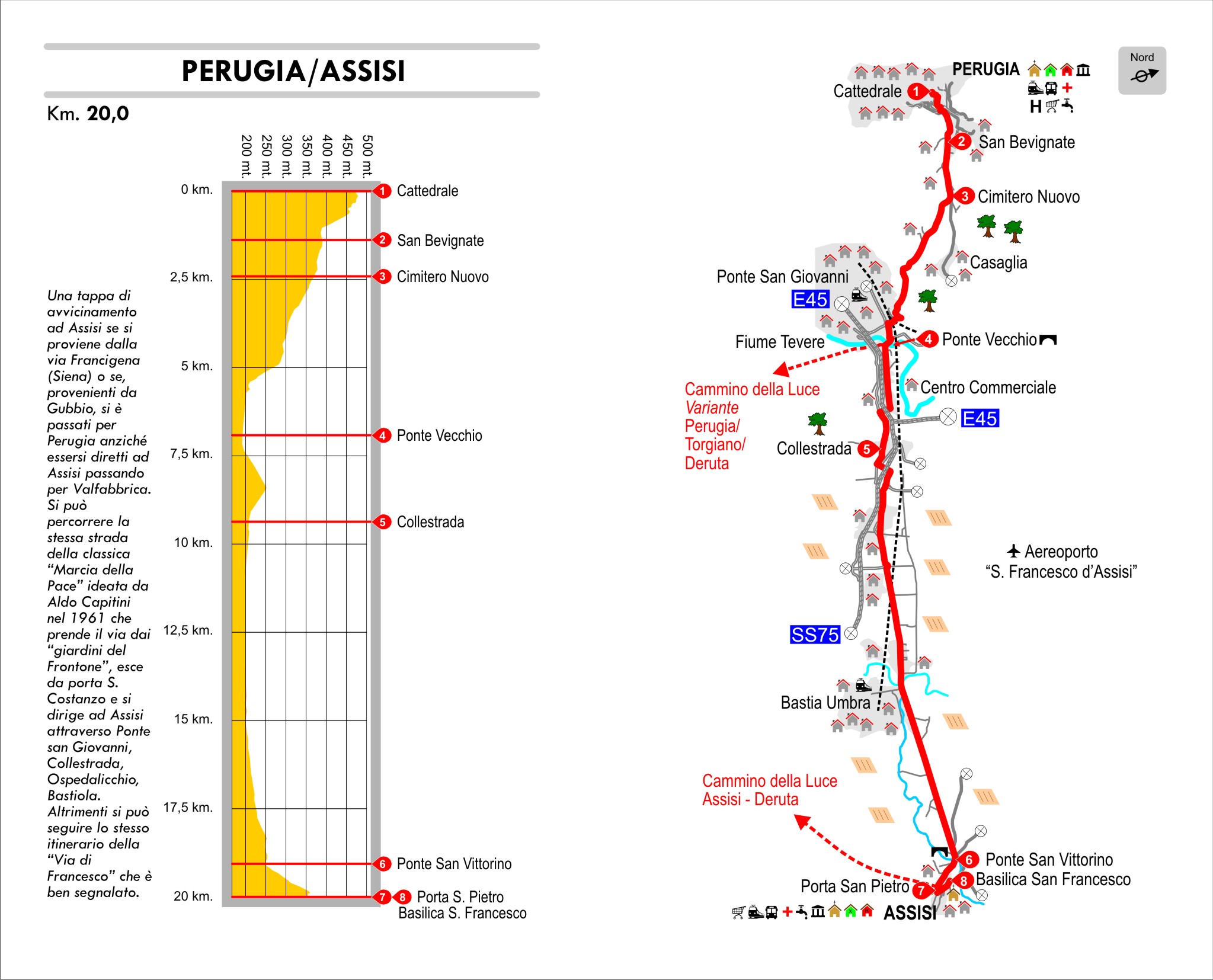
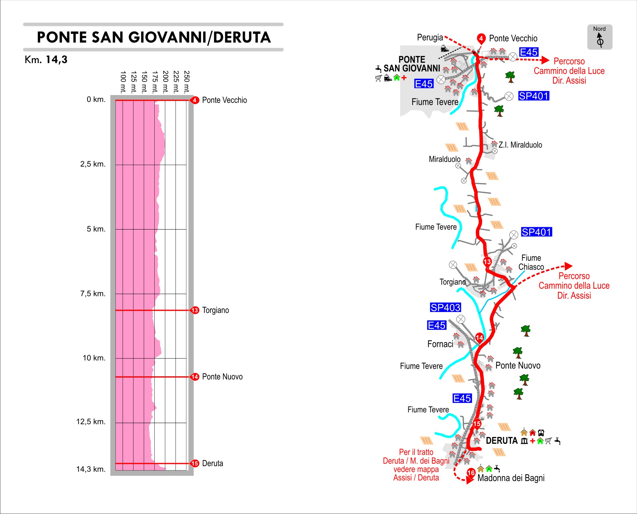
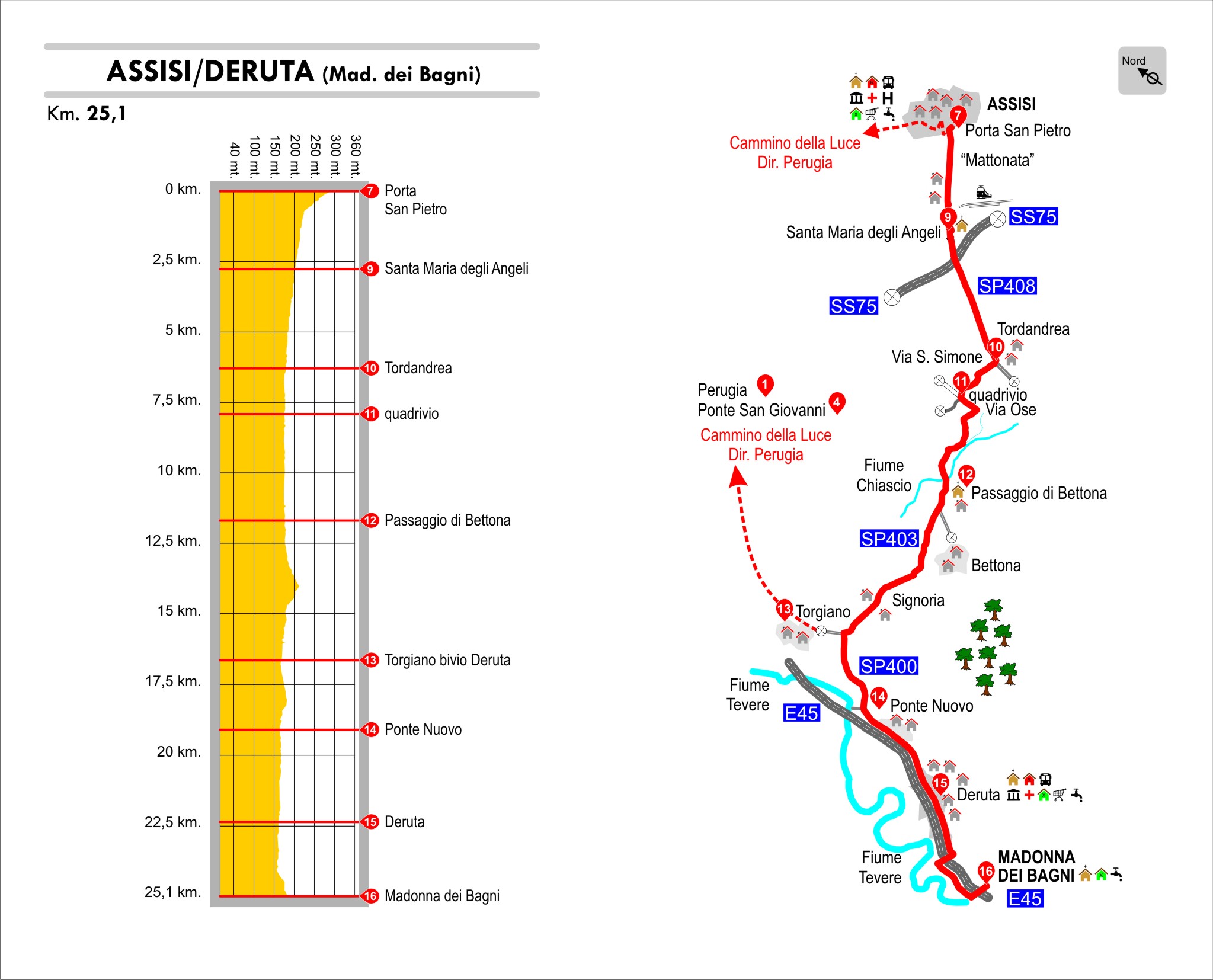
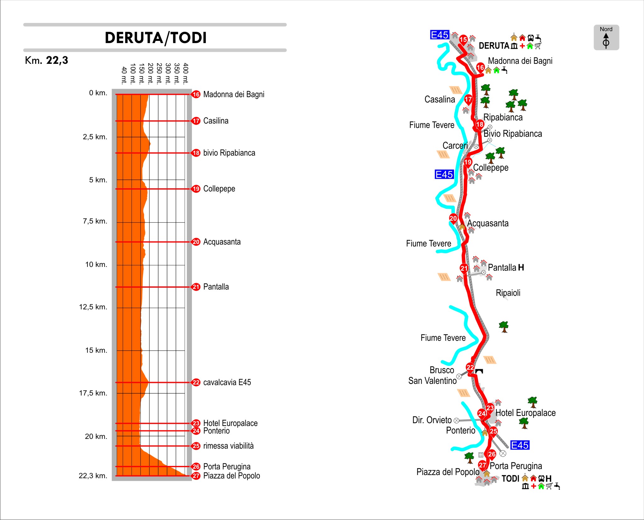
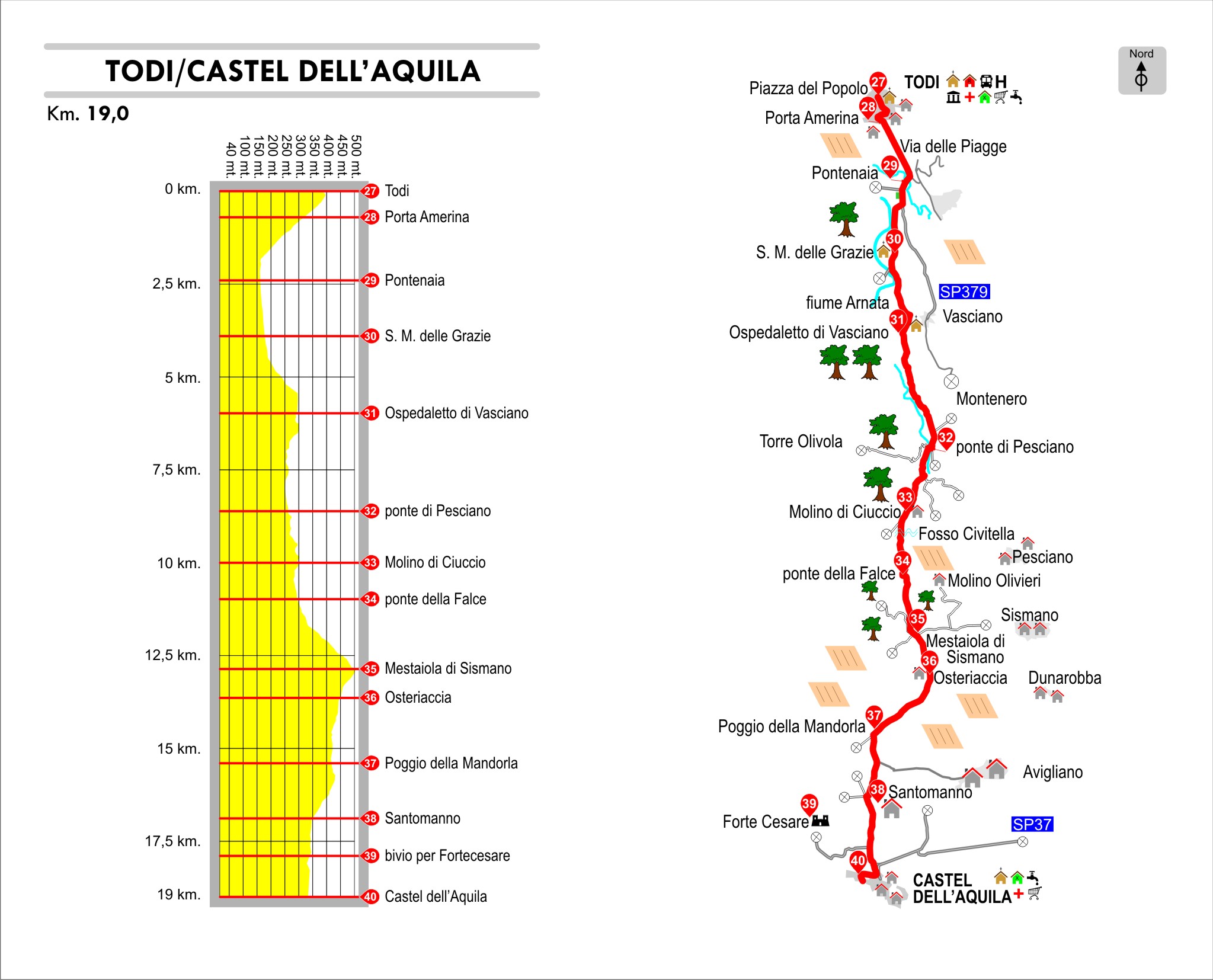
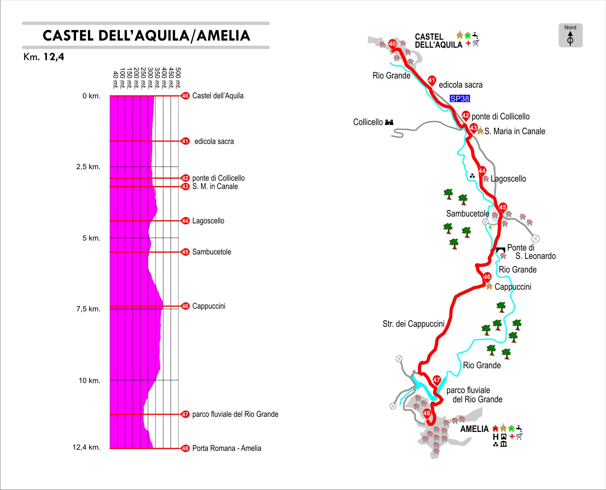
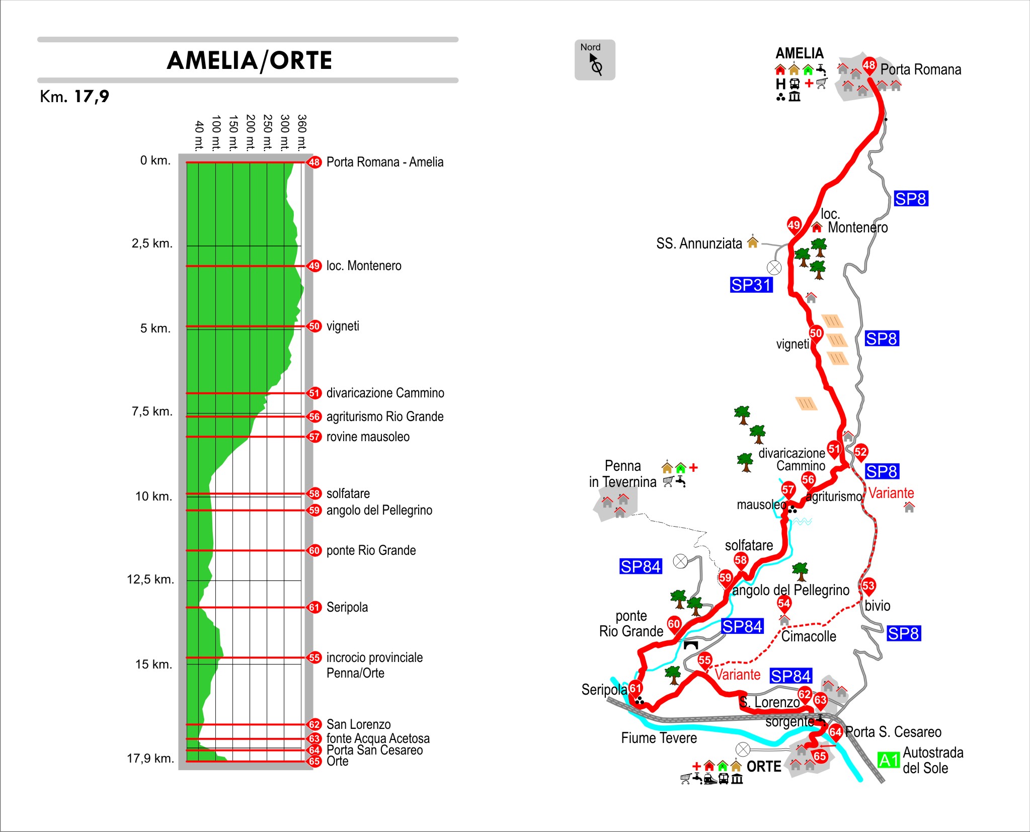
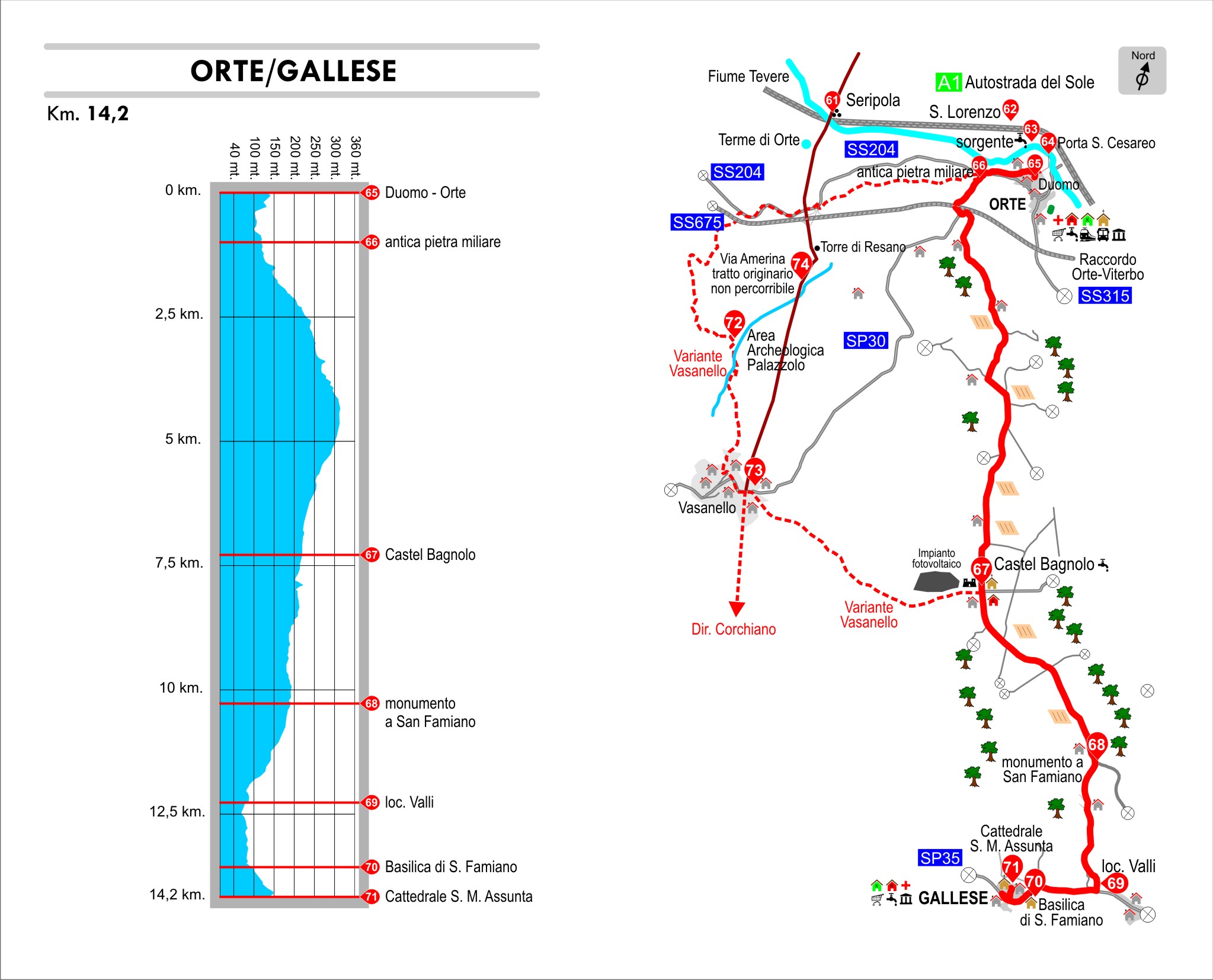
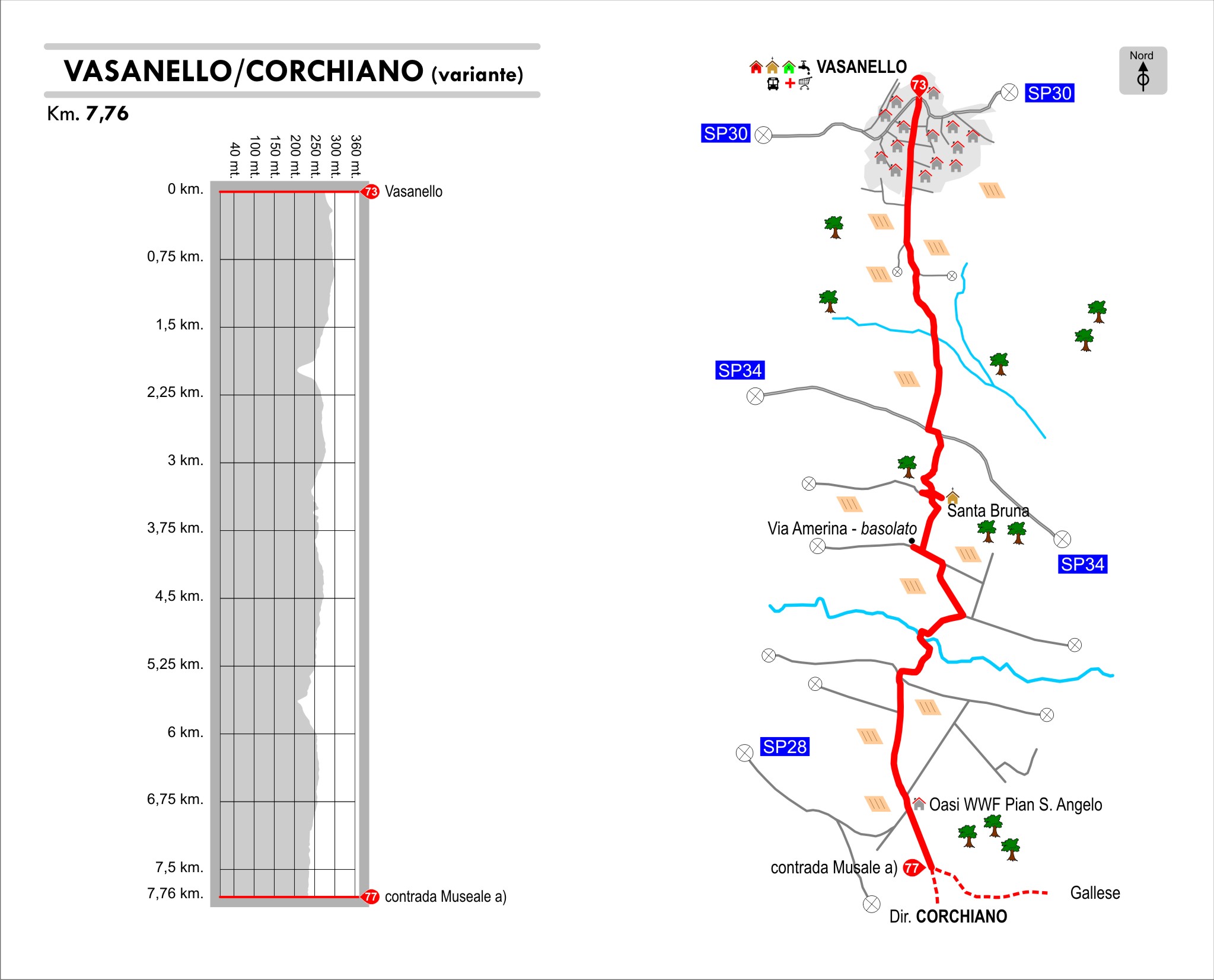
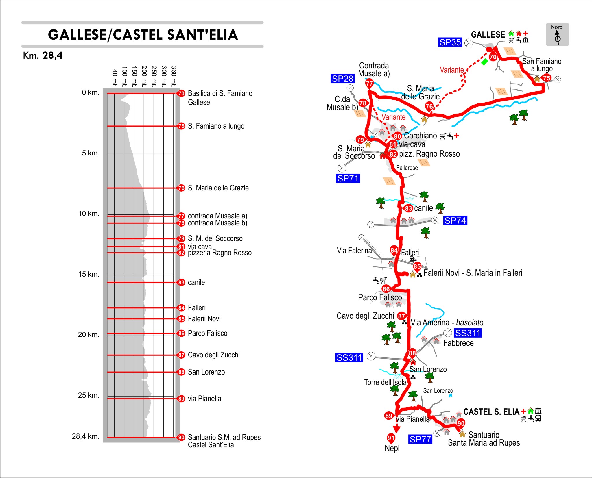
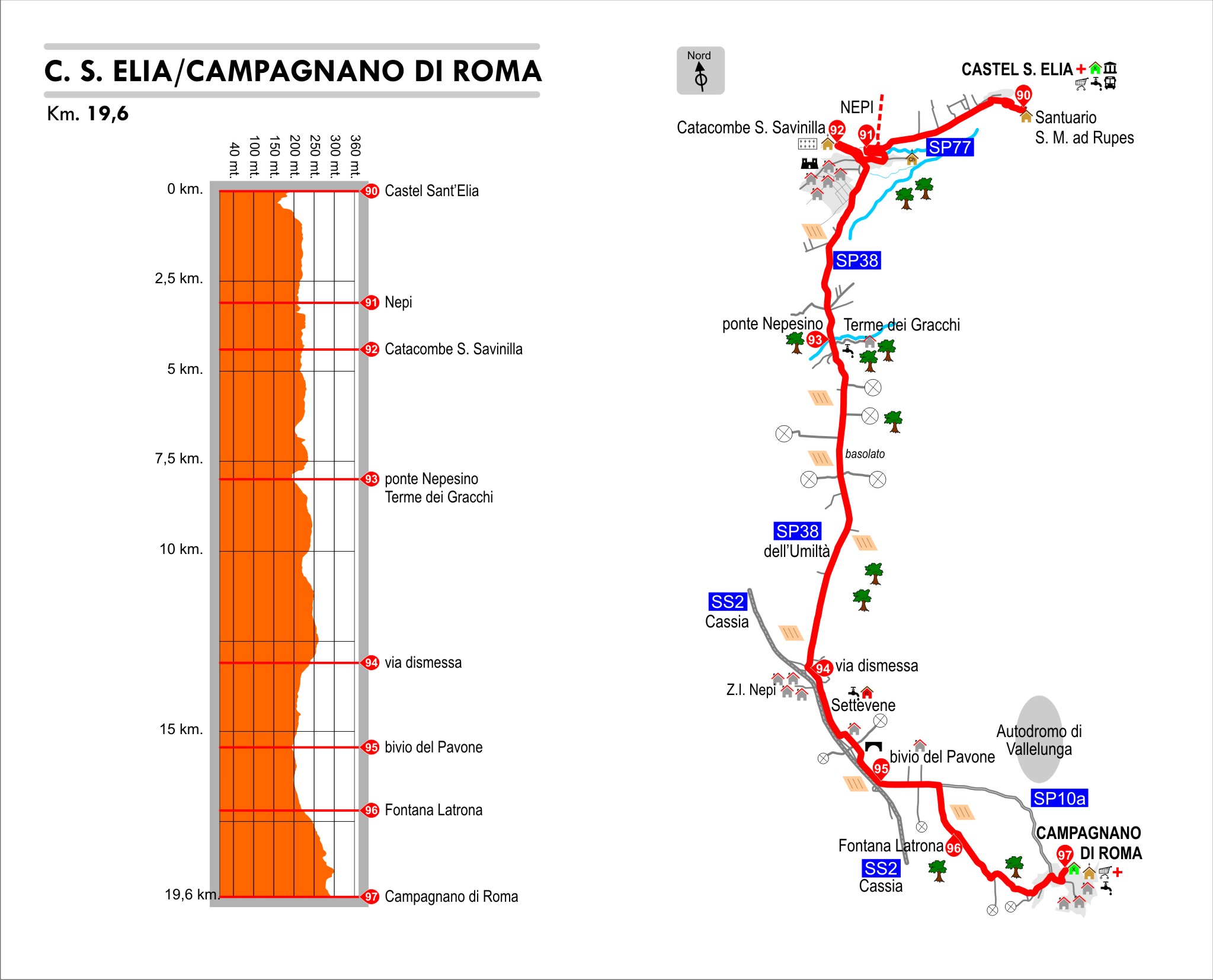
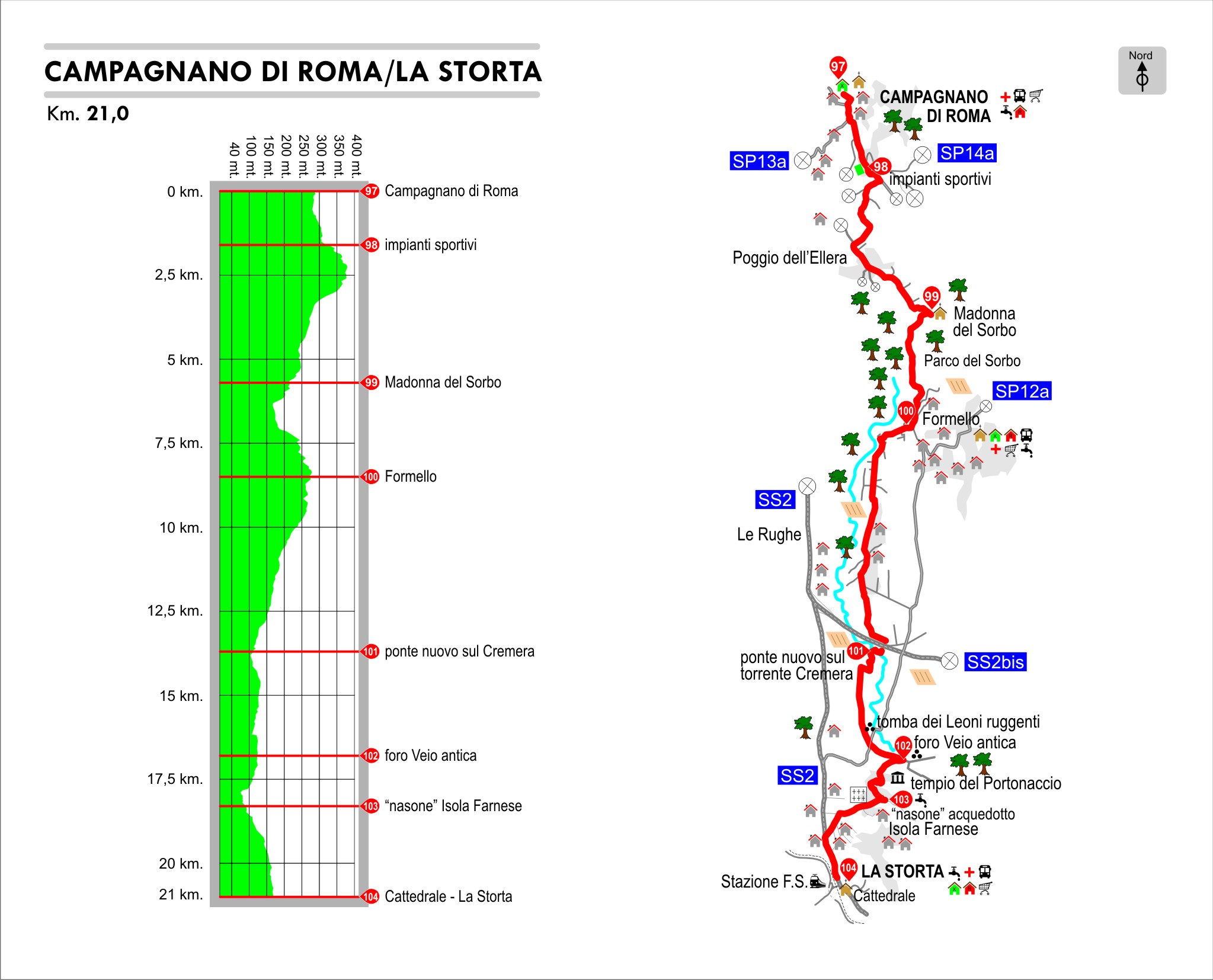
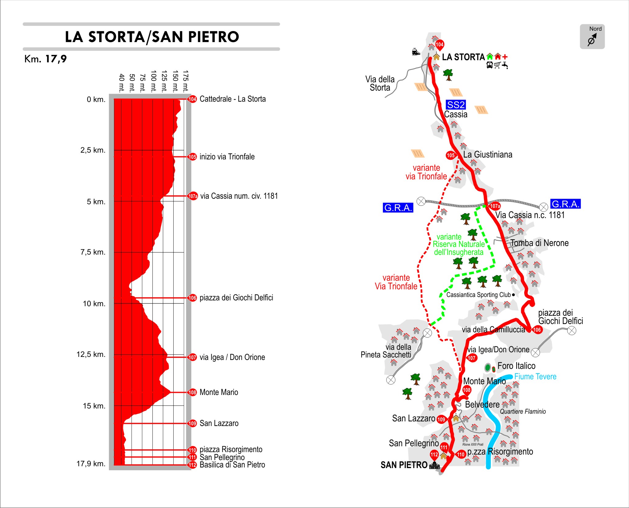
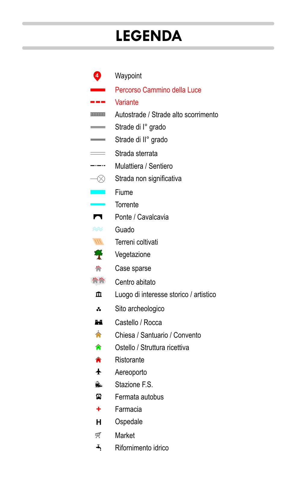
GPS
Click below to download the complete file of Perugia/Assisi–Rome route. The track is divided into stages and integrated with the landmarks.

